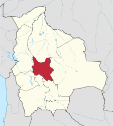
Department of Cochabamba
| Cochabamba | |||
|---|---|---|---|
| Symbols | |||
|
|||
| Basic data | |||
| Country | Bolivia | ||
| Capital | Cochabamba | ||
| surface | 55,631 km² | ||
| Residents | 1,758,143 (2012 census) | ||
| density | 32 inhabitants per km² | ||
| ISO 3166-2 | BO-C | ||
Coordinates: 17 ° 20 ′ S , 65 ° 30 ′ W
The department of Cochabamba ( Quechua Quchapampa suyu ) is located in the geographical center of Bolivia . It has an area of 55,631 km² and a population of 1,758,143 (2012). The main town is the city of the same name, Cochabamba .
Geography and economics
Cochabamba borders in the north on Beni , in the east on Santa Cruz , in the southeast on Chuquisaca , in the south on Potosí , in the southwest on Oruro and in the west on La Paz . While the western and central parts of the department are part of the Altiplano , the northeastern areas ( Chapare Province ) are only 300 m above sea level in the transition area to the tropical rainforest .
Cochabamba was and is an important producer of corn and wheat in Bolivia. In the lowlands of the northeast, the cultivation of coca is of economic importance.
population
The population of the department has increased fourfold over the past six decades:
| year | Residents | source |
|---|---|---|
| 1950 | 452 145 | census |
| 1976 | 720 952 | census |
| 1992 | 1 110 205 | census |
| 2001 | 1,455,711 | census |
| 2012 | 1 758 143 | census |
Of the 1,455,711 inhabitants of the department of Cochabamba at the time of the 2001 census, 856,409 lived in urban areas and 599,302 in rural areas. With 26.17 inhabitants per km², the department of Cochabamba is the most densely populated department of Bolivia. 74.36% of the population over 15 years of age (64.27% in urban and 90.65% in rural areas) consider themselves to be members of Indian peoples . According to the 2001 census, 81.52% of residents over 6 years of age speak Spanish (95.87% in urban areas and 59.89% in rural areas).
Provinces
The department of Cochabamba is divided into 16 provinces (the number of inhabitants at the time of the 2001 census follows the name of the province):
- Arani Province 24.053
- Arque Province 23,464
- Ayopaya Province 60,959
- Bolívar Province 8,635
- Capinota Province 25,582
- Carrasco Province 116.205
- Province of Cercado 517.024 (includes the city of Cochabamba )
- Chapare Province 187.358
- Esteban Arce Province 31,997
- Germán Jordán Province 31,768
- Mizque Province 36,181
- Narciso Province Campero 37.011
- Punata Province 47,735
- Quillacollo Province 246,803
- Tapacarí Province 25,919
- Tiraque Province 35,017
Biggest cities
| city | Population 2001 (census) |
Inhabitants 2010 (update) |
|---|---|---|
| Cochabamba | 516,683 | 624,850 |
| Sacaba | 92,581 | 105,726 |
| Quillacollo | 74,980 | 85,739 |
| Colcapirhua | 41,637 | 47,728 |
| Tiquipaya | 26,732 | 30,675 |
politics
Overall result in the department of Cochabamba in the regional elections on April 4, 2010:
| electoral legitimate |
electoral participation |
valid votes | MAS-IPSP | UN-CP | MSM | MNR | ||
|---|---|---|---|---|---|---|---|---|
| 939.903 | 819.601 | 671.186 | 415.245 | 174.175 | 52,516 | 29,250 | ||
| 87.2% | 81.9% | 61.9% | 26.0% | 7.8% | 4.4% |
Individual evidence
- ↑ a b c d Instituto Nacional de Estadística (INE) ( Memento of the original from February 26, 2014 in the Internet Archive ) Info: The archive link has been inserted automatically and has not yet been checked. Please check the original and archive link according to the instructions and then remove this notice.
- ↑ INE - Instituto Nacional de Estadística Bolivia 2012 ( Memento of the original from March 4, 2016 in the Internet Archive ) Info: The archive link was inserted automatically and has not yet been checked. Please check the original and archive link according to the instructions and then remove this notice.
- ↑ Acta de computo Nacional Electoral Departamentales, Municipales y Regional 2010


