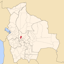
Quillacollo Province
| Quillacollo Province | |
|---|---|
 |
|
| Basic data | |
| Country | Bolivia |
| Department | Cochabamba |
| Seat | Quillacollo |
| surface | 720 km² |
| Residents | 335,999 (2012) |
| density | 467 inhabitants per km² |
| ISO 3166-2 | BO-C |
Coordinates: 17 ° 20 ′ S , 66 ° 15 ′ W
Quillacollo is a province in the southwestern part of the Cochabamba department in the South American Andean state of Bolivia .
location
The province is one of sixteen provinces in the department of Cochabamba. It borders in the northwest on the province of Ayopaya , in the northeast on the province of Chapare , in the east on the province of Cercado , in the southeast on the province of Capinota , in the south on the province of Arque and in the west on the province of Tapacarí .
The province extends between about 17 ° 03 'and 17 ° 42' south latitude and 66 ° 02 'and 66 ° 30' west longitude, its extension from west to east is 30 kilometers, from north to south 75 kilometers.
Together with Cercado and Sacaba , Quillacollo forms the Kanata metropolitan region, which was founded in 2014 .
population
The population of the province of Quillacollo has more than doubled in the past two decades:
| year | Residents | source |
|---|---|---|
| 1992 | 145.197 | census |
| 2001 | 246,803 | census |
| 2012 | 335.999 | census |
41.2 percent of the population are younger than 15 years, the literacy rate in the province is 86.1 percent. (1992)
90.2 percent of the population speak Spanish , 71.9 percent Quechua , and 0.6 percent Aymara . (1992)
22.5 percent of the population have no access to electricity , 53.0 percent live without sanitary facilities (1992) .
88.0 percent of the population are Catholic , 8.3 percent are Protestant (1992) .
structure
The province of Quillacollo is divided into five municipalities :
- 03-0901 Municipio Quillacollo - 137,029 inhabitants ( 2001: 104,206 inhabitants )
- 03-0902 Municipio Sipe Sipe - 41,537 inhabitants ( 2001: 31,337 inhabitants )
- 03-0903 Municipio Tiquipaya - 53,668 inhabitants ( 2001: 37,791 inhabitants )
- 03-0904 Municipio Vinto - 51,869 inhabitants ( 2001: 31,489 inhabitants )
- 03-0905 Municipio Colcapirhua - 51,896 inhabitants ( 2001: 41,980 inhabitants )
Localities in the province of Quillacollo
- Municipio Quillacollo
- Quillacollo 117,859 pop - Pandoja 6611 pop - El Paso 5964 pop - Cotapachi 774 pop - Apote (El Paso) 520 pop - Apote (Pasomayu) 499 pop .
- Municipio Sipe Sipe
- Sipe Sipe 11,826 inh. - Parotani 2434 inh. - Mallco Rancho 1919 inh. - Coachaca Chico 1782 inh. - Mallco Chapi 1776 inh. - Vinto Chico 1711 inh. - Huañacahua 1598 inh. - Sauce Rancho 1574 inh. - Payacollo 1,127 inhabitants. - Suticollo 1015 pop - Tajra 996 pop - Itapaya 744 pop - Valle Hermoso 638 pop - Sorata 607 pop - Sindicato Pirhuas 587 pop - Viloma Cala Cala 574 pop - Collpa Centro 548 pop - Sindicato Siqui Siquia 538 Pop - Pirque 484 pop
- Municipio Tiquipaya
- Tiquipaya 49,237 pop - Chapisirca 562 pop
- Municipio Vinto
- Municipio Colcapirhua
- Colcapirhua 51,896 pop.
Individual evidence
- ↑ 533 Creación de la Región Metropolitana Kanata - Cochabamba (May 27, 2014)
- ↑ Cedib on Región Metropolitana Kanata - Cochabamba (May 27, 2014)
- ^ INE - Instituto Nacional de Estadística Bolivia 1992
- ^ INE - Instituto Nacional de Estadística Bolivia 2001
- ^ INE - Instituto Nacional de Estadística Bolivia 2012
Web links
- Department of Cochabamba - Social data (PDF 7.77 MB) ( Spanish )
- Municipio Colcapirhua - detailed map and population data (PDF; 200 kB) ( Spanish )
- Municipio Quillacollo - detailed map and population data (PDF; 434 kB) ( Spanish )
- Municipio Sipe Sipe - detailed map and population data (PDF; 440 kB) ( Spanish )
- Municipio Tiquipaya - detailed map and population data (PDF; 377 kB) ( Spanish )
- Municipio Vinto - detailed map and population data (PDF; 295 kB) ( Spanish )