
La Paz Department (Bolivia)
| La Paz | |||
|---|---|---|---|
  |
|||
| Symbols | |||
|
|||
| Basic data | |||
| Country | Bolivia | ||
| Capital | La Paz | ||
| surface | 133,985 km² | ||
| Residents | 2,706,351 (2012 census) | ||
| density | 20 inhabitants per km² | ||
| ISO 3166-2 | BO-L | ||


Coordinates: 15 ° 0 ′ S , 68 ° 20 ′ W
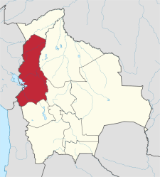
The Bolivian department of La Paz is located in the west of the country on the border with Peru and covers 133,985 km² and has 2,706,351 inhabitants (2012). The most important cities are the city of La Paz (capital of the department and seat of government of Bolivia) and the neighboring El Alto .
geography
The western and southwestern parts of the department belong to the high plateau of the Altiplano . The Bolivian part of Lake Titicaca and the up to 6600 m high Cordillera Real belong to it . To the northeast of the Cordillera are the Yungas , two elongated valleys on the eastern slope of the Andes , which form the transition to the Amazon lowlands. They are only about 1000 m above sea level and are the most important supplier for supplying La Paz and El Altos with fruit and vegetables . Almost the entire northern half belongs to the tropical lowlands and is only very sparsely populated.
The important ruins of Tiahuanaco are located southwest of the department capital .
population
The population of the department has more than tripled in the past 65 years:
| year | Residents | source |
|---|---|---|
| 1950 | 854 079 | census |
| 1976 | 1,465,078 | census |
| 1992 | 1 900 786 | census |
| 2001 | 2,350,466 | census |
| 2012 | 2 706 351 | census |
Of the 2,350,466 inhabitants of the La Paz department at the time of the 2001 census, 1,552,146 lived in urban areas and 798,320 in rural areas. Most of the urban population lives in the two cities of La Paz and El Alto . 77.46% of the population over 15 years of age (70.19% in urban and 92.47% in rural areas) counted themselves to the members of Indian peoples. The majority of them belong to the Aymara , whose main settlement area is the department of La Paz together with the neighboring department of Oruro and the neighboring areas of Peru . According to the 2001 census, 88.47% of residents over 6 years of age speak Spanish (96.69% in urban areas and 72.25% in rural areas).
Provinces

The La Paz Department is divided into 20 provinces:
| No. | province | 2001 residents | Residents 2012 | note |
|---|---|---|---|---|
| 1 | Abel Iturralde Province | 11,828 | 18,073 | |
| 2 | Provincial flavor | 86,480 | 97.364 | |
| 3 | Bautista Saavedra Province | 11,475 | 16.308 | |
| 4th | Caranavi Province | 51,153 | 59,365 | |
| 5 | Franz Tamayo Province | 18,386 | 26,997 | |
| 6th | Gualberto Villarroel Province | 15,975 | 17,782 | |
| 7th | Eliodoro Camacho Province | 57,745 | 53,747 | |
| 8th | Ingavi Province | 95.906 | 134,535 | |
| 9 | Inquisivi Province | 59,495 | 66,346 | |
| 10 | José Manuel Pando Province | 6.137 | 7,381 | |
| 11 | Larecaja Province | 68.026 | 86,473 | |
| 12 | Loayza Province | 43,731 | 47,295 | |
| 13 | Los Andes Province | 69,636 | 77,579 | |
| 14th | Manco Kapac Province | 22,892 | 27,154 | |
| 15th | Muñecas Province | 25.163 | 25.193 | |
| 16 | Nor Yungas Province | 23,681 | 36,983 | |
| 17th | Omasuyos Province | 85,702 | 84,484 | |
| 18th | Pacajes Province | 49.183 | 55,180 | |
| 19th | Murillo Province | 1,484,328 | 1,663,099 | includes u. a. the cities of La Paz and El Alto |
| 20th | South Yungas Province | 63,544 | 105.013 |
Biggest places
| city | Population 2001 (census) |
Population 2012 (census) |
|---|---|---|
| La Paz | 792.611 | 757.184 |
| El Alto | 695.243 | 842,378 |
| Viacha | 29,108 | 62,516 |
| Achocalla | 10,369 | 18,442 |
| Caranavi | 12,318 | 13,569 |
| Patacamaya | 10,007 | 11,197 |
| Achacachi | 7,560 | 8,857 |
politics
Overall result in the La Paz department in the regional elections on April 4, 2010:
| electoral legitimate |
electoral participation |
valid votes | MAS-IPSP | MSM | U.N. | MPS | ASP | MNR | ||
|---|---|---|---|---|---|---|---|---|---|---|
| 1,504,037 | 1,339,676 | 1,069,234 | 534.563 | 247,796 | 159,499 | 67,863 | 30,361 | 29,152 | ||
| 89.1% | 79.8% | 50.0% | 23.2% | 14.9% | 6.3% | 2.8% | 2.7% |
tourism
In the department of La Paz are the ruins of Tiahuanaco , one of the world's most famous landmarks. Also, the Lake Titicaca and the mountainous region of Chacaltaya be visited by thousands of tourists.
Individual evidence
- ↑ a b c d Instituto Nacional de Estadística (INE) ( Memento of the original from February 26, 2014 in the Internet Archive ) Info: The archive link has been inserted automatically and has not yet been checked. Please check the original and archive link according to the instructions and then remove this notice.
- ↑ INE - Instituto Nacional de Estadística Bolivia 2012 ( Memento of the original from March 4, 2016 in the Internet Archive ) Info: The archive link was inserted automatically and has not yet been checked. Please check the original and archive link according to the instructions and then remove this notice.
- ↑ Acta de computo Nacional Electoral Departamentales, Municipales y Regional 2010
Web links
- Information about the department on the website of the Bolivian Embassy in Berlin
- Website of the Prefecture of the Department of La Paz (Spanish)
- Flag of La Paz
Beni | Chuquisaca | Cochabamba | La Paz | Oruro | Pando | Potosí | Santa Cruz | Tarija