
Pando Department
| Pando Department | ||
|---|---|---|
  |
||
| Symbols | ||
|
||
| Basic data | ||
| Country | Bolivia | |
| Capital | Cobija | |
| surface | 63,827 km² | |
| Residents | 110,436 (2012 census) | |
| density | 1.7 inhabitants per km² | |
| founding | 09/24/1938 | |
| ISO 3166-2 | BO-N | |
 |
||

Coordinates: 11 ° 11 ′ S , 67 ° 11 ′ W
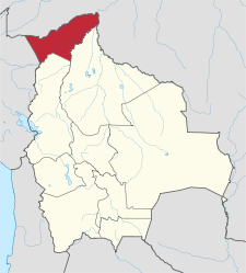
The Bolivian Department of Pando is located in the north of Bolivia and borders on Brazil in the north and Peru in the west . It has an area of 63,827 km², the capital is Cobija .
geography
Pando lies in the flat lowlands of the Amazon basin . It has a tropical hot and humid climate with an annual rainfall of 1,800 mm.
Southwest of Pando joins the La Paz Department and the Beni Department to the southeast .
history
Pando was founded on September 24, 1938 as the youngest Bolivian department of the then existing "colonization area Northwest" (Territorio de Colonias del Noroeste) and was named in honor of the 25th President of Bolivia José Manuel Pando , in whose term of office (1899-1904 ) the border between Bolivia and Brazil was established after violent conflicts around the rubber-rich jungle region.
population
Due to its remote location in the tropical rainforest, Pando is only sparsely populated. The population of the department has increased more than six times over the past sixty years:
| year | Residents | source |
|---|---|---|
| 1950 | 16,284 | census |
| 1976 | 34,493 | census |
| 1992 | 38,072 | census |
| 2001 | 52,525 | census |
| 2012 | 110,436 | census |
Provinces

Pando is divided into five provinces (population according to the 2012 census):
- Abuná Province - 4,049 inhabitants
- Federico Román Province - 7,034 inhabitants
- Madre de Dios Province - 24,070 inhabitants
- Manuripi Province - 14,986 inhabitants
- Nicolás Suárez province - 60,297 inhabitants (includes the city of Cobija)
Cities
| city | Population 2001 (census) |
Inhabitants 2010 (update) |
|---|---|---|
| Cobija | 20,820 | 47,692 |
| Porvenir | 1,730 | 2,925 |
| Puerto Rico | 1,522 | 2,573 |
economy
The main branches of industry are the rubber industry and the extraction of Brazil nuts and high-quality tropical woods.
Infrastructure
The main traffic routes are the navigable rivers. The only road connection to the rest of the country leads to the neighboring department of Beni and is not always passable during the rainy season. Another road connection to the La Paz department is planned. There is an airport in the capital, Cobija.
politics
The local public holiday is September 24th (the day the department was founded). The flag of the Departamento Pando is white and green.
The following results were achieved in the regional elections of April 4, 2010 in the Pando Department:
| electoral legitimate |
electoral participation |
valid votes | MAS-IPSP | CP | MSM | ||
|---|---|---|---|---|---|---|---|
| 43,359 | 37.053 | 34,593 | 17.192 | 16,744 | 657 | ||
| 85.5% | 93.4% | 49.7% | 48.4% | 1.9% |
Web links
- Information about the department on the website of the Bolivian Embassy in Berlin
- Prefectura de Pando (Spanish)
- Portal Bolivia (Spanish)
- Story of Pandos (Spanish)
- Boliviacorazón.com.ar (Spanish)
- Atlas de Salud 2008 Departamento de Pando (PDF; 1.87 MB; Spanish) accessed December 3, 2015
Individual evidence
- ↑ a b c d Instituto Nacional de Estadística (INE) ( Memento of the original from February 26, 2014 in the Internet Archive ) Info: The archive link has been inserted automatically and has not yet been checked. Please check the original and archive link according to the instructions and then remove this notice.
- ↑ INE - Instituto Nacional de Estadística Bolivia 2012 ( Memento of the original from March 4, 2016 in the Internet Archive ) Info: The archive link was inserted automatically and has not yet been checked. Please check the original and archive link according to the instructions and then remove this notice.
- ↑ Acta de computo Nacional Electoral Departamentales, Municipales y Regional 2010
Beni | Chuquisaca | Cochabamba | La Paz | Oruro | Pando | Potosí | Santa Cruz | Tarija