Achocalla
| Achocalla | ||
|---|---|---|
 Achocalla facing east to the Río de la Paz |
||
| Basic data | ||
| Residents (state) | 18,442 pop. (2012 census) | |
| rank | Rank 36 | |
| height | 3762 m | |
| Post Code | 02-0104-0100-1001 | |
| Telephone code | (+591) | |
| Coordinates | 16 ° 34 ′ S , 68 ° 10 ′ W | |
|
|
||
| politics | ||
| Department | La Paz | |
| province | Murillo Province | |
| climate | ||
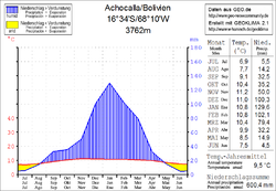
 Climate diagram Achocalla |
||
Achocalla is a small town in the La Paz department in the South American Andean state of Bolivia .
Location in the vicinity
Achocalla is the center of the municipality of the same name Achocalla and is located in the province of Murillo , twenty kilometers southwest of the capital La Paz . The city is located at an altitude of 3762 m, about the same as the center of La Paz and around 200 meters below the El Alto plateau .
geography
Achocalla is located on the eastern edge of the Bolivian Altiplano and is dominated to the east by the peaks of the Cordillera Real , which rises here with the Illimani heights of almost 6500 meters. The climate of the region is a typical daytime climate , in which the mean temperature fluctuations between day and night are more pronounced than in the course of the seasons.
The annual average temperature of Achocalla is 9.5 ° C (see climate diagram Achocalla), the monthly values fluctuate between 7 ° C in July and 11 ° C from November to February. The annual precipitation is 600 mm, the climate is arid in the winter months from May to August with monthly values of less than 15 mm, while in the summer months from December to February between 100 and 130 mm precipitation falls.
Transport network
Achocalla is twenty kilometers by road south of La Paz , the capital of the department, and is connected to the capital by two different road links.
Access to Achocalla is via the national road Ruta 2 , which leads from the La Paz basin in a westerly direction to the plateau to El Alto . From there you follow Ruta 1 for six kilometers to the south and then leave the Altiplano again on serpentines three kilometers down the valley to the center of Achocalla.
Another access leads from La Paz directly to the south along the Río de la Paz in the direction of the suburb Mallasa and branches off at Mallasilla in a western direction to Achocalla .
population
Achocalla belongs to the direct catchment area of the metropolis of La Paz and therefore shows rapid population growth, the number of inhabitants has more than doubled in the past two decades. Between 2001 and 2012 Amachuma was incorporated into Achocalla.
| year | Residents | source |
|---|---|---|
| 1992 | approx. 5 600 | census |
| 2001 | 10 369 | census |
| 2012 | 18 442 | census |
Individual evidence
- ^ INE - Instituto Nacional de Estadística Bolivia 1992 ( Memento from April 23, 2014 in the Internet Archive )
- ^ INE - Instituto Nacional de Estadística Bolivia 2001 ( Memento from November 29, 2014 in the Internet Archive )
- ^ INE - Instituto Nacional de Estadística Bolivia 2012 ( Memento from March 4, 2016 in the Internet Archive )
Web links
- Relief map of the La Paz region 1: 250,000 (PDF; 11.07 MB)
- Municipio Achocalla - General Maps No. 20104
- Municipio Achocalla - detailed map and population data (PDF; 784 kB) ( Spanish )
- Departamento La Paz - social data of the municipalities (PDF; 11.63 MB) ( Spanish )
