Sacaba
| Sacaba | ||
|---|---|---|
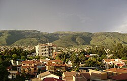
 View over the city |
||
| Basic data | ||
| Residents (state) | 149,563 pop. (2012 census) | |
| rank | Rank 9 | |
| height | 2719 m | |
| Post Code | 03-1001-0100-1001 | |
| Telephone code | (+591) 4 | |
| Coordinates | 17 ° 24 ′ S , 66 ° 2 ′ W | |
|
|
||
| politics | ||
| Department | Cochabamba | |
| province | Chapare Province | |
| mayor | Luis Orellana Rojas | |
| climate | ||
 Climate diagram Cochabamba |
||
Sacaba (more precisely: Villa de San Pedro de Sacaba ) is a city in the department of Cochabamba in the South American Andean state of Bolivia . The city is the second largest city in the Cochabamba region after Cochabamba and one of the fastest growing cities in Bolivia. The city was founded on June 29, 1761.
Location in the vicinity
Sacaba is the seat of the administration of the province of Chapare and a central place in the district ( Bolivian : Municipio ) Sacaba . The city lies at an altitude of 2719 m on the southern edge of the Cordillera of Cochabamba in the eastern part of the plain of Cochabamba.
geography
Sacaba is located on the western edge of the Andes mountain range of the Cordillera Oriental in a valley region halfway between the Altiplano and Chapare lowlands, which is also known as the region of eternal spring.
The climate is warm and temperate and has a mean average temperature of almost 18 ° C (see climate diagram Cochabamba), the monthly values fluctuate only slightly between 14 ° C in June / July and almost 20 ° C from October to December. The annual precipitation is only about 450 mm, with a pronounced dry season from May to September with monthly precipitation below 10 mm, and a short humidity period from December to February with 90-120 mm monthly precipitation.
Transport network
Sacaba is 16 kilometers east of the city of Cochabamba by road.
The highway Ruta 4 runs through Sacaba, with a length of 1,657 kilometers, which crosses the entire country in a west-east direction. The road begins in the west at Tambo Quemado on the Chilean border and reaches Sacaba after 392 kilometers . The road then continues in an easterly direction via Santa Cruz to Puerto Suárez in the Brazilian border area. Apart from the last 700 kilometers to the east, the road is paved throughout.
population
The city's population exploded, especially in the 1980s and 1990s, and made the city grow into a major city within a few decades:
| year | Residents | source |
|---|---|---|
| 1976 | 5 554 | census |
| 1992 | 36 905 | census |
| 2001 | 92 581 | census |
| 2012 | 149 563 | census |
Despite the high degree of urbanization, a large part of the population has retained its Quechua identity; in the Municipio Sacaba, 65.2 percent of the population speak the Quechua language.
economy
Most of the residents of Sacaba work in the city of Cochabamba. Local industries include food and shoe production and the like. a. Numerous traditional small manufacturing companies and the full festival calendar have made Sacaba known as the city "where corn beer ( chicha ) never runs out". In addition, the only legal coca wholesale market for the extensive production from the Chapare province is located in Sacaba .
politics
Sacaba was the scene of violent riots against the destruction of coca cultivation in 2002, as a result of which Evo Morales , leader of the Cocalero movement, party chairman of the MAS and since 2006 president of the country Bolivia, had to give up his seat in the Bolivian Congress. The closure of the coca market in Sacaba at the time and the subsequent street protests resulted in several deaths on both sides.
Individual evidence
- ↑ Thomas Brinkhoff: City Population
- ^ INE - Instituto Nacional de Estadística Bolivia 1992
- ^ INE - Instituto Nacional de Estadística Bolivia 2001
- ↑ INE - Instituto Nacional de Estadística Bolivia 2012 ( Memento of the original from March 4, 2016 in the Internet Archive ) Info: The archive link was inserted automatically and has not yet been checked. Please check the original and archive link according to the instructions and then remove this notice.
- ↑ INE social data 2001 (PDF; 12.2 MB)
- ↑ Los Tiempos, March 9, 2017 ( Spanish )
Web links
- Raised relief map Cochabamba 1: 100,000 (PDF; 10.6 MB)
- Municipio Sacaba - detailed map and population data (PDF; 471 kB) ( Spanish )
- Department of Cochabamba - Social data (PDF; 7.58 MB) ( Spanish )
