Charcas Province
| Charcas Province | |
|---|---|
 |
|
| Basic data | |
| Country | Bolivia |
| Department | Potosí |
| Seat | San Pedro de Buena Vista |
| surface | 2964 km² |
| Residents | 40,882 (2012) |
| density | 14 inhabitants per km² |
| ISO 3166-2 | BO-P |
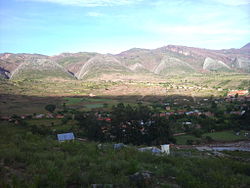
| View of the municipality of Toro Toro | |
Coordinates: 18 ° 17 ′ S , 65 ° 53 ′ W
Charcas is a province in the Potosí department in the highlands of the South American Andean state of Bolivia .
location
The province of Charcas is one of sixteen provinces in the Department of Potosí. It lies between 17 ° 57 'and 18 ° 36' south latitude and between 65 ° 21 'and 66 ° 19' west longitude . It borders in the north with the province of Bernardino Bilbao , in the north-west with the province Alonso de Ibáñez , in the south-west with the province Rafael Bustillo , in the south with the province Chayanta , and in the east with the department Cochabamba . The province extends for about 125 kilometers in an east-west direction and 100 kilometers in a north-south direction.
population
The population of the province of Charcas has increased by almost a third over the past two decades:
- 1992 : 31,233 inhabitants ( census )
- 2001 : 38,174 inhabitants (census)
- 2012 : 40,882 inhabitants (census)
The capital and largest city of the province is San Pedro de Buena Vista with 1,131 inhabitants. ( 2012 )
structure
The province is divided into the following two districts ( Bolivian : Municipios ):
- 05-0501 Municipio San Pedro de Buena Vista - 30,012 inhabitants ( 2012 census )
- 05-0502 Municipio Toro Toro - 10,870 inhabitants
Localities in the province of Charcas
- Municipio of San Pedro de Buena Vista
- San Pedro de Buena Vista pop 1131 - Chiro Kasa pop 651 - Toracarí pop 561 - Jatun Jila pop 508 - Pocoatillo pop 261 - Cusumi pop 236 - Micani pop 197 - San Marcos pop 49
- Municipio Toro Toro
Individual evidence
- ↑ Instituto Nacional de Estadística (INE) 1992
- ^ Instituto Nacional de Estadística (INE) 2001
- ↑ Instituto Nacional de Estadística (INE) 2012 ( Memento of the original of July 22, 2011 in the Internet Archive ) Info: The archive link has been inserted automatically and has not yet been checked. Please check the original and archive link according to the instructions and then remove this notice.
Web links
- Potosí Department - Social data (PDF 5.36 MB) ( Spanish )
- Municipio San Pedro - detailed map and population data (PDF; 1 MB) ( Spanish )
- Municipio Toro Toro - detailed map and population data (PDF; 911 kB) ( Spanish )
