New York State Route 17A

|
|
|---|---|
| Basic data | |
| Overall length: | 24.76 mi. / 39.85 km |
| Opening: | 1930 |
| Starting point: |
|
| End point: |
|
| County: | Orange County |
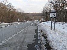
New York State Route 17A is a state route in southern New York in the United States , the entire course of which lies in Orange County . The west end is in Goshen at an intersection with New York State Route 17 and the east end is at another intersection with that State Route in Southfields . Between Warwick and Florida , the route runs jointly with New York State Route 94 . The main road serves to connect Warwick to the rest of the county. NY 17A is an east-west route, but several sections run north-south. The meandering route allows the driver a view of the landscape.
The State Route was part of the New York State Route 55 route in the 1920s with the nearby New York State Route 210 . When renumbering in 1930, the current route was shown.
Route
NY 17A begins south of Exit 124 on State Route 17 in Goshen. At the traffic lights on the south ramp to NY 17 heading east, New York State Route 207 becomes NY 17A. The road climbs rapidly into the mountainous areas south of Goshen, where views not only of Orange County's Black Dirt region but also of Pochuck Mountain and High Point , which are further south in New Jersey . The road slowly leads back down into the valley, past rolling meadows and farmland, before reaching the small town of Florida, where New York State Route 94 joins shortly after entering the town from the west . Both run through Florida together as a main street.
Outside the village , NY 17A and NY 94 lead again into the mountains, this time the panoramic view is directed north to Shawangunk Ridge and, if the visibility is clear enough, even to the Catskill Mountains behind. In this section the road is relatively undeveloped, between Florida and Warwick there is only one gas station. NY 17A and NY 94 also form the main street in this town. Many of the historic buildings in the Warwick Village Historic District border NY17A / NY94 within the resort. The two country roads separate on the eastern edge of the village. While NY 94 continues towards New Jersey, NY turns east.
Over the next few kilometers, the route leads back into the hills, passes a nature park and the small ski area on Mount Peter and crosses the Appalachian Trail at the ridge of Bellvale Mountain . From here the route leads back down into the valley and bends to reach Greenwood Lake , where NY 210 branches off to lead along Greenwood Lake to the state border with New Jersey.
From Greenwood Lake, NY 17A runs over another ridge and widens into a four-lane median strip that runs through Sterling Forest to the east end of the highway in Southfields. The road leads as County Route 106 eastwards through the Orange and Rockland counties to the intersection with US Highway 9W / US Highway 202 in Stony Point . County Route 106 was originally part of NY 210 before changing to Greenwood Lake.
history
In the late 1920s, today's NY 17A between Greenwood Lake and Goshen was signposted as New York State Route 55 , which served as the connection between New York State Route 17 and New Jersey. When renumbered in 1930, the then NY 55 was taken over in two longer routes: NY 210 from the state border from New Jersey to Greenwood Lake and NY 17A from Greenwood Lake to Goshen. To the east of Greenwood Lake, NY 17A takes a previously unnumbered highway to complete this alternative route to NY 17. This section of NY 17A overlaid NY 210, which led past NY 17A's endpoint to Stony Brook. This overlap was lifted sometime between 1977 and 1985.
See also
Web links
Individual evidence
- ↑ 2007 Traffic Data Report for New York State ( English , PDF) New York State Department of Transportation . P. 124. July 25, 2008. Retrieved February 14, 2009.
- ^ A b Leon A. Dickinson: New Signs for State Highways (English) . In: The New York Times , Jan. 12, 1930, p. 136.
- ↑ a b c d Google Maps. Overview map of NY 17A [map]. Cartography from NAVTEQ. Retrieved February 14, 2009.
- ^ Automobile Blue Book , (Automobile Blue Books Inc., Chicago, 1927), Vol. 1
- ^ Automobile Blue Book - Volume Three . Automobile Blue Books, Inc. 1929. Retrieved March 4, 2008.
- ^ Automobile Legal Association (ALA) Automobile Green Book , 1930/31 and 1931/32, (Scarborough Motor Guide Co., Boston, 1930 and 1931). The 1930/31 edition shows the State Routes in New York before the renumbering.
- ^ Rand McNally : Road Map & Historical Guide - New York . Sun Oil Company , 1935.
- ↑ Exxon (1977). New York [map], 1977-78.
- ↑ Rand McNally (1985) (in English). New York [map]. ISBN 0-528-91040-X .

