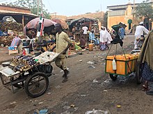
Niamey-Bas
Niamey-Bas is a district of Niamey in Niger .
geography
Niamey-Bas ( French for "Nieder-Niamey") is located in the city center on the Niger River , in parts of the arrondissements of Niamey II and Niamey III . It roughly encompasses the Terminus and Zongo districts as well as the eastern part of the Kombo district and the western part of the Maourey district . The standard scheme for street names in Niamey-Bas is rue NB 1 , with the abbreviation NB in the French rue for streetfor Niamey-Bas and finally a number follows. This goes back to a project to name streets in Niamey in 2002, in which the city was divided into 44 zones, each with its own letter abbreviations.
history
The city of Niamey was founded in its current form through the establishment of a French military post in 1902/1903. This military post and the resulting European settlement were originally located in the Niamey-Bas area. After a fire in the neighboring indigenous settlement and because of the heavy immigration due to a famine in 1932, a new European settlement was finally built in the Plateau district in 1937 and the site in Niamey-Bas was abandoned.
After Niger gained independence in 1960, Plateau retained the function of the administrative center of the entire state, while Niamey-Bas acted as a trading center. The district received new life in the 1960s with the construction of a housing estate by the state bank Crédit du Niger , which was intended to alleviate the housing shortage in the city. The Gawèye district in Niamey-Bas was moved to the other bank of the Niger River in 1979 to make space for representative buildings. In the 1980s, Niamey-Bas temporarily formed a joint administrative district (quartier) with the area around the National Museum .
literature
- Kokou Henri Motcho: Niamey, Garin Captan Salma ou l'histoire du peuplement de la ville de Niamey . In: Jérôme Aloko-N'Guessan, Amadou Diallo, Kokou Henri Motcho (eds.): Villes et organization de l'espace en Afrique . Karthala, Paris 2010, ISBN 978-2-8111-0339-2 , pp. 15-37 .
Individual evidence
- ↑ Catherine Farvacque-Vitkovic, Lucien Godin, Hugues Leroux, Florence Verdet, Roberto Chavez: Street Addressing and the Management of Cities . World Bank, Washington, DC 2005, ISBN 0-8213-5815-4 , pp. 85 and 89 .
- ↑ Kokou Henri Motcho: Niamey, Garin captan Salma ou l'histoire du peuplement de la ville de Niamey . In: Jérôme Aloko-N'Guessan, Amadou Diallo, Kokou Henri Motcho (eds.): Villes et organization de l'espace en Afrique . Karthala, Paris 2010, ISBN 978-2-8111-0339-2 , pp. 16 and 18 .
- ^ Manzo Mahamane: Croissance urbaine et politique de peuplement au Niger . In: Croissance demographique et urbanization. Politiques de peuplement et aménagement du territoire. Séminaire international de Rabat (15-17 May 1990) . Association Internationale des demographes de langue française, Paris 1993, ISBN 2-7332-7012-5 , p. 382 .
- ↑ Kokou Henri Motcho: Niamey, Garin captan Salma ou l'histoire du peuplement de la ville de Niamey . In: Jérôme Aloko-N'Guessan, Amadou Diallo, Kokou Henri Motcho (eds.): Villes et organization de l'espace en Afrique . Karthala, Paris 2010, ISBN 978-2-8111-0339-2 , pp. 29 .
- ↑ Kokou Henri Motcho: Niamey, Garin captan Salma ou l'histoire du peuplement de la ville de Niamey . In: Jérôme Aloko-N'Guessan, Amadou Diallo, Kokou Henri Motcho (eds.): Villes et organization de l'espace en Afrique . Karthala, Paris 2010, ISBN 978-2-8111-0339-2 , pp. 30-31 .
Coordinates: 13 ° 30 ' N , 2 ° 7' E

