Nieuwer Ter Aa
| province |
|
| local community |
|
| Residents | 695 (Jan. 1, 2017) |
| Coordinates | 52 ° 11 ′ N , 4 ° 59 ′ E |
| Important traffic route |
|
| prefix | 0294 |
| Postcodes | 3621, 3626, 3631-3632, 3634, 3645 |
| Website | Homepage of Nieuwer Ter Aa |
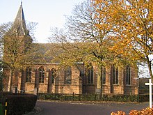
Nieuwer Ter Aa is a Dutch village in the municipality of Stichtse Vecht , province of Utrecht and is located on the small river de Aa . "Nieuwer Ter Aa" and "Oud Aa" are named after him. The place has 695 inhabitants (as of January 1, 2017). There is much evidence that Nieuwer Ter Aa has existed for 1000 years. The late Gothic village church from the 15th century (picture) stands on the site of an older Romanesque church; in the brick walls, the tuff stones are processed as volumes. Before 1964 the village belonged to the former municipalities of Ruwiel and Loenersloot , after it belonged to Breukelen until 2011 .
Nieuwer Ter Aa is not far from the Amsterdam Rijn Canal . The hamlets "Oud-Aa" and "Oukoop" are also part of the village.
further reading
- AA Manten, M. Laméris, Breukelen. Geschiedenis en Architectuur . Monument inventory Provincie Utrecht. (About the story of, inter alia, Nieuwer Ter Aa). Uitgeverij Kerckebosch, Zeist 2008. ISBN 978-90-6720-443-9
Web links
Commons : Nieuwer Ter Aa - collection of images, videos and audio files
- Place website (Dutch)
Individual evidence
- ↑ a b Kerncijfers wijken en buurten 2017 Centraal Bureau voor de Statistiek , accessed on April 3, 2018 (Dutch)
- ↑ ( Page no longer available , search in web archives: History of Breukelen and Nieuwer Ter Aa )


