Normanna Strait
| Normanna Strait | ||
|---|---|---|
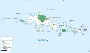
| Map of the South Orkney Islands with the Normanna Strait between Signy Island and Coronation Island (center) | ||
| Connects waters | Weddell Sea | |
| with water | Orwell Bight | |
| Separates land mass | Signy Island | |
| of land mass | Coronation Island | |
| Data | ||
| Geographical location | 60 ° 40 '59 " S , 45 ° 36' 58" W | |
|
|
||
| Smallest width | 1.6 km | |
The Normanna Strait is a 1.6 km wide strait in the archipelago of the South Orkney Islands . It separates Signy Island in the south from Coronation Island in the north .
This passage was discovered by the British captain Matthew Brisbane (1787-1833), who reached the South Orkney Islands together with James Weddell in January 1823. The name appears for the first time on maps based on the measurements of the Norwegian captain Petter Sørlle between 1912 and 1913. It is probably named after the whaling ship D / S Normanna from the Norwegian Sandefjord .
Web links
- Normanna Strait in the Geographic Names Information System of the United States Geological Survey (English)
- Normanna Strait on geographic.org (English)
Individual evidence
- ↑ D / S Normanna , information and photos on sjohistorie.no (Norwegian, accessed June 14, 2017).

