Orwell Bight
| Orwell Bight | ||
|---|---|---|
|
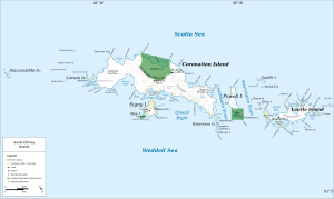
Map of the South Orkney Islands with Orwell Bight (center) |
||
| Waters | Weddell Sea | |
| Land mass | South Orkney Islands | |
| Geographical location | 60 ° 43 '59 " S , 45 ° 24' 58" W | |
|
|
||
| Islands | Simeonov Island | |
The Orwell Bight is a bay in the archipelago of the South Orkney Islands . It is located south of the eastern half of Coronation Island and is bounded by Signy Island to the west and the Robertson Islands to the east.
The Norwegian whaling captain Petter Sørlle was the first to map the bay between 1912 and 1913. Scientists from the British Discovery Investigations conducted surveys in 1933. The Falkland Islands Dependencies Survey repeated this between 1948 and 1949. The UK Antarctic Place-Names Committee named the bay in 1955 after the transport ship Orwell of the Norwegian whaling company Tønsbergs Hvalfangeri , which operated between 1926 and 1926 and between 1929 and 1930 in the waters around the Southern Orkney Islands operated.
Web links
- Orwell Bight in the Geographic Names Information System of the United States Geological Survey (English)
- Orwell Bight on geographic.org (English)

