
Oberried (Sonthofen)
|
Oberried
City of Sonthofen
Coordinates: 47 ° 31 ′ 9 ″ N , 10 ° 19 ′ 31 ″ E
|
|
|---|---|
| Height : | 1068 m |
| Residents : | 0 (2017) |
The disappeared mountain village of Oberried was a district of Sonthofen .
It was first mentioned in documents in 1136. In 1889 the village was given up due to the difficult management and the long way to school for the children. At that time Oberried consisted of seven courtyards and a chapel . This chapel is the only one that has been preserved and has since been renovated several times. Today, on the site of a former farm, there is a rest and information hut with texts and pictures on the history of the place.
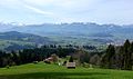
Oberried
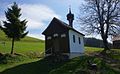
Oberried Chapel
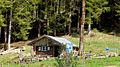
Rest and information hut Oberried


Individual evidence
- ^ Oberried at Heimatdienst Sonthofen eV , accessed on April 13, 2017
- ↑ Experience Oberried near Allgäu , accessed on April 13, 2017