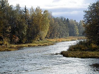
Ogre (river)
|
Ogre Огре, ogre |
||
| Data | ||
| location | Latvia | |
| River system | Daugava | |
| Drain over | Düna → Baltic Sea | |
| source | Sivēniņs 56 ° 58 '45 " N , 26 ° 6' 26" O |
|
| muzzle | at Ogre in the Düna (Daugava) coordinates: 56 ° 48 '39 " N , 24 ° 36' 6" O 56 ° 48 '39 " N , 24 ° 36' 6" O
|
|
| length | 176 km (according to other sources: 188 km) | |
| Catchment area | 1700 km² (according to other sources: 1730 km²) | |
| Outflow location: 20 km above the mouth |
MQ |
17.7 m³ / s |
| Drain |
MQ |
17.9 m³ / s |
| Right tributaries | Līčupe , Aviekste | |
|
Ogre (Огре) in the catchment area of the Daugava |
||
The Ogre ( Russian Огре ; German name: Oger ) is a 176 km long right tributary of the Daugava in Latvia .
The river rises on the heights near Piebalga and is fed by several lakes. The entire run is winding. Up to Ērgļi there is a steeper gradient with incised banks. Further down the river is navigable with canoes. The estuary is near the city of Ogre .
- The largest tributaries are Līčupe (40 km) and Aviekste (28 km).
- In ancient times the river was also called Wogene or Woga .
Web links
Commons : Ogre - collection of images, videos and audio files
Individual evidence
- ↑ a b c Article Ogre in the Great Soviet Encyclopedia (BSE) , 3rd edition 1969–1978 (Russian)
- ↑ a b c Nicodemus Oļģerts: Latvijas fiziskā ģeogrāfija, section Latvijas lielākās upes


