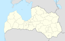
Ērgļi
| Ērgļi sds | ||
|---|---|---|
 |
|
|
| Basic data | ||
| State : |
|
|
| Landscape: | Livonia ( Latvian : Vidzeme ) | |
| Administrative district : | Ērgļu novads | |
| Coordinates : | 56 ° 54 ' N , 25 ° 38' E | |
| Residents : | 1.939 | |
| Area : | 131.4 km² | |
| Population density : | 15 inhabitants per km² | |
| Height : | 170 m | |
| Website: | www.ergli.lv | |
| Post Code: | ||
| ISO code: | ||
Ērgļi (German Erlaa ) is a small town in northeast Latvia on the banks of the Ogre .
history
One of the largest castles in Latgale was located on the Ogre . From 1211 the area belonged to the Order of the Brothers of the Sword and later to the Archdiocese of Riga . The first written mention of a castle took place in 1334. After the Livonian War , the area fell to Poland-Lithuania, then to Sweden and in 1721 to Russia .
The village developed around the Erlaa estate and in 1931 had 331 inhabitants. During the Second World War , the place was in the battle zone in 1944 and was completely destroyed. In the post-war period the place grew due to the settlement of industry.
Others
- 3 km away from Ērgļi you can visit the birthplace of the playwright Rūdolfs Blaumanis .
- From 1937 to 2009 there was a railway line that ended in Ērgļi coming from Riga.
- The ruins of the Erlaa Ordensburg are located in the center of the village in the floodplains of the Oger River
Twin town
- Kölln-Reisiek (Germany)
Ērgļu novads
In 2006 the city and two surrounding communities merged to form an administrative unit. In 2010, 3535 inhabitants were registered (see also: Administrative division of Latvia )
literature
- Hans Feldmann , Heinz von zur Mühlen (Hrsg.): Baltic historical local dictionary, part 2: Latvia (southern Livland and Courland). Böhlau, Cologne 1990, ISBN 3-412-06889-6 , pp. 153-154.
- Astrīda Iltnere (ed.): Latvijas Pagasti, Enciklopēdija. Preses Nams, Riga 2002, ISBN 9984-00-436-8 .
