Oki-daitō
| Oki-daitō | ||
|---|---|---|
| Satellite image of Oki-daitō | ||
| Waters | Philippine Sea | |
| Archipelago | Daitō Islands | |
| Geographical location | 24 ° 28 '2 " N , 131 ° 11' 16" E | |
|
|
||
| length | 1.5 km | |
| surface | 1.15 km² | |
| Highest elevation | 33 m | |
| Residents | uninhabited | |
| Map of Oki-daitō | ||
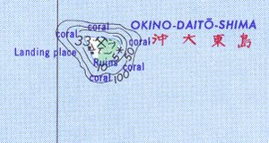
Oki-daitō ( Japanese 沖 大 東 島 , -jima / -shima , literally: "remote Daitō island", formerly: Rasa , ラ サ 島 , Rasa-tō ) is the southernmost island of the Japanese Daitō islands in the Philippine Sea . Administratively, the island belongs to the municipality of Kitadaitō of Okinawa Prefecture .
geography
The uninhabited island is comparatively isolated around 150 km south of Minami-daitō , the largest island in the archipelago, and 160 km south of Kita-daitō , from which it is administered. It is 408 km away from Naha on Okinawa , the seat of the prefecture. Like all Daitō Islands is also Okidaitōjima an upscale Atoll with a steep cliff coastline of limestone - the former fringing reef of the atoll - as well as a deeper level - the former lagoon - inside the island. Oki-daitō is roughly triangular in shape with a circumference of about 4.5 kilometers and has an area of 1.15 km². The island, surrounded by a coral reef , reaches a height of up to 33 m above sea level on the coast .
history
It is possible that the island was discovered on May 8, 1643 by the Dutch Maarten Gerritszoon Vries and Hendrik Corneliszoon Schaep during an expedition and named Breskens Eylant . Despite wrong coordinates , a sighting of the British captain John Meares on April 5, 1788, who named the islands Grampus Isles , is considered certain. In 1815 the island was rediscovered by sailors from the Spanish frigate San Fernando de Magallanes . She was baptized Isla Rasa and her position was correctly determined. In 1900 Japan first raised its claim to the island and had guano intensively mined by the specially founded Rasa-tō Rinkō KK ( ラ サ 島 燐 礦 heute , today: Rasa Kōgyō KK ). During this time, from 1911 to 1945, Oki-daitō was inhabited by up to 2000 people; a settlement was in the west of the island. After the Second World War , the island was used as a firing range by the United States Navy .
Web links
- Side of Rasa Industries over Okidaitōjima (English)
- Short portrait at oceandots.com ( Memento from December 23, 2010 in the Internet Archive ) (English)
Individual evidence
- ↑ 島 面積 . (PDF; 136 kB) (No longer available online.) Kokudo Chiriin , October 1, 2015, archived from the original on June 15, 2016 ; Retrieved August 2, 2016 (Japanese). Info: The archive link was inserted automatically and has not yet been checked. Please check the original and archive link according to the instructions and then remove this notice.


