Orosí
| Orosí | ||
|---|---|---|
|
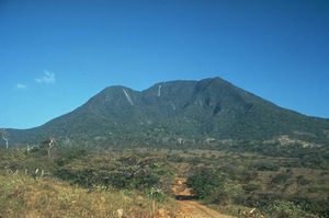
The highest mountain in the Orosí volcanic complex is the Volcán Cacao. The summit crater of the Cacao, 5.5 km southeast of the actual Orosí, is broken through on the southwest side shown here as a result of a landslide. |
||
| height | 1659 m | |
| location | Province of Guanacaste , Costa Rica | |
| Mountains | Cordillera de Guanacaste | |
| Coordinates | 10 ° 58 '48 " N , 85 ° 28' 24" W | |
|
|
||
| Type | extinct stratovolcanoes | |
| Last eruption | about 3500 years ago | |
The Orosí is a complex of extinct stratovolcanoes in the northwest of Costa Rica . It is located in the Guanacaste National Park , near the border with Nicaragua . The actual Orosí has a conical shape with, however, heavily eroded flanks. The complex consists of the stratovolcanoes Orosí, Orosilito, Pedregal and Cacao. The highest mountain is the 1659 m high Cacao, 5.5 km southeast of the actual Orosí. The age of the last volcanic activity of the Orosí is unknown. According to historical reports, the Orosí erupted in 1844 and 1849, but even at the time of the first volcanological observations at the end of the nineteenth century, the Orosí was overgrown with large trees and the eruptions most likely took place at the neighboring Rincón de la Vieja . The most recent recorded volcanic activity on the Orosí produced lahars 3,500 years ago . The area around the volcano is a popular tourist destination mainly because of its great biodiversity.
At the base of the mountain is the Maritza Biological Station, a research facility that conducts studies on tropical ecosystems. It was founded in 1989 with the help of the Stroud Water Research Center in Avondale, Pennsylvania.
Web links
- Orosí in the Global Volcanism Program of the Smithsonian Institution (English)
- Stroud Water Research Center (English)

