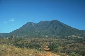
Guanacaste National Park
|
Guanacaste
|
||
|
The volcano Cacao |
||
| location | Guanacaste , Costa Rica | |
| surface | 338 km² | |
| WDPA ID | 19368 | |
| Geographical location | 10 ° 50 ′ N , 85 ° 19 ′ W | |
|
|
||
| Setup date | 1991 | |
The Guanacaste National Park ( Spanish Parque Nacional Guanacaste ) is an area of around 338 km² between the coast and the mountains in northwest Costa Rica .
geography
The national park is located in the Guanacaste province of the same name . It is the northwesternmost province of Costa Rica with Liberia as the capital.
target
The Guanacaste National Park was established in 1989 to connect the Santa Rosa National Park with the high-altitude cloud forests around the Orosi Cacao volcano with the Caribbean rainforests in northern Costa Rica. This should also create a network of habitats for large mammals such as the jaguar and mountain lions. At the same time, the aim was to create a “biological corridor” for birds and insects to allow them to migrate between the different habitats in a seasonal manner.
fauna and Flora
The original vegetation of much of the park consisted of dry forests . Most of these were destroyed and replaced by grass species imported from Africa .
Individual evidence
- ↑ http://costa-rica-guide.com/nature/national-parks/guanacaste-np/
- ^ Andre P. Dobson: Biological diversity and nature protection . 1997, p. 244 ff .


