Osiris (moon crater)
| Osiris | ||
|---|---|---|

|
||
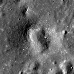
| Osiris (image of the Lunar Reconnaissance Orbiter ) | ||
|
|
||
| position | 18.63 ° N , 27.66 ° E | |
| diameter | 1 km | |
| Card sheet | 42 (PDF) | |
| Named after | Egyptian male name | |
| Named since | 1976 | |
| Unless otherwise stated, the information comes from the entry in the IAU / USGS database | ||
Osiris is a very small volcanic crater on the front of the moon on the border of Mare Serenitatis and Mare Tranquillitatis , northeast of Dawes crater and west of Fabrioni .
The name goes back to an originally unofficial name on sheet 42C3 / S2 of the Topophotomap map series from NASA , which was taken over by the IAU in 1976.

Osiris and surroundings (photo Apollo 17 )
Web links
Individual evidence
- ↑ Weitz CM, Head JW: Spectral properties of the Marius Hills volcanic complex and implications for the formation of lunar domes and cones . In: Journal of Geophysical Research . 104, No. E8, 1999, pp. 18933-18956. bibcode : 1999JGR ... 10418933W . doi : 10.1029 / 1998JE000630 .
- ↑ Topophotomap 42C3 / S2
- ^ Excerpt from the Proceedings of the 16th General Assembly of the IAU (Grenoble 1976). In: Transactions of the IAU vol. XVIB, edited by D. Riedel, 1977
