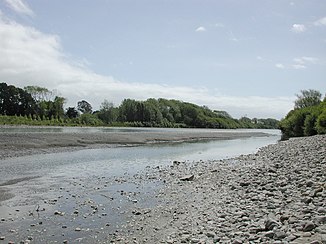
Otaki River
| Otaki River | ||
|
Otaki River at Otaki |
||
| Data | ||
| location | North Island (New Zealand) | |
| River system | Otaki River | |
| muzzle | at Otaki on the Kapiti Coast in the Tasman Sea Coordinates: 40 ° 45 ′ 32 ″ S , 175 ° 6 ′ 5 ″ E 40 ° 45 ′ 32 ″ S , 175 ° 6 ′ 5 ″ E
|
|
The Otaki River is a river on the southwestern North Island of New Zealand .
It rises in the mountains of the Tararua Ranges and flows in a valley of these mountains 45 km to the southwest. He passes Mount Crawford on its east side. Then it makes a big curve and then flows north-west. Several tributaries, including the Waiotauru River, flow into the river near Otaki Forks .
After it has passed under the railway line and New Zealand State Highway 1 and passed the center of Otaki in the south, it flows into the Tasman Sea on the coastal section called Kapiti Coast . Between Otaki and Otaki Forks is a gorge in which the Otaki Gorge Road leads up to Otaki Forks.
Otaki Forks is a popular and very popular recreation area with campsites and walking trails, as well as the starting point for several hikes in the Tararua Mountains.
Web links
- "New Zealand Travel Atlas", Wise Maps Auckland. ISBN 0-908794-47-9 .
