Otaki (New Zealand)
| Otaki | ||
| Geographical location | ||
|
|
||
| Coordinates | 40 ° 46 ′ S , 175 ° 9 ′ E | |
| Region ISO | NZ-WGN | |
| Country |
|
|
| region | Wellington | |
| District | Kapiti Coast District | |
| Ward | Otaki Ward | |
| Residents | 5 778 (2013) | |
| height | 13 m | |
| Post Code | 5512 | |
| Telephone code | +64 (0) 4 | |
| UN / LOCODE | NZ OTA | |
| Photography of the place | ||
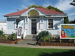
 Otaki Tourist Information |
||
Otaki is a town in the Kapiti Coast District of Wellington on the North Island of New Zealand .
Origin of name
The name of the city comes from the Māori language and is composed of " O " for place and " taki " for stick.
geography
The city is located around 19 km southwest of Levin and around 65 km north-northeast of Wellington on the coast of the Kapiti Coast . The city has access to the coast via Otaki Beach , which is around 4 km northwest of Otaki city center . To the east of the city are the Tararua Range , from which the Otaki River flows westwards, passes Otaki to the south and flows into the Tasman Sea around 4 km west .
history
The city emerged from a Māori settlement . The area on the coast was often contested and so the tribes in the area changed depending on the balance of power. In 1820 the area was conquered by Te Rauparaha , a chief of the Ngāti Toa . His tribe and the tribes of the Ngāti Raukawa and Ngāti Awa intermingled and settled from the Whangaehu River to the Otaki area . Since then the Iwi of the Ngāti Raukawa has ruled the area around Otaki .
Te Rauparaha was interested in the faith represented by the Church Missionary Society , and so a missionary station was founded in the Māori settlement in 1839 by the missionary and later Bishop of Wellington , Octavius Hadfield . It was also Te Rauparaha who had the University of Raukawa built in the settlement between 1845 and 1849 , which was considered the first Māori university in the country, but fell victim to a fire in 1995.
In 1858 the first stagecoach service was established between Wanganui and Wellington and Otaki became a stopover. The place got connection to the railway network with the completion of the railway line from Wellington to Longburn , today located southwest of Palmerston North . In 1912 Otaki became a so-called Town District and was granted Borough status on April 1, 1921 .
population
In the 2013 census, the town had 5,778 inhabitants, 5.7% more than in the 2006 census.
economy
Otaki and the surrounding area live mainly from agriculture, with commercial horticulture, vegetable growing and livestock farming in the foreground. The city's commercial operations are primarily geared towards agriculture.
Infrastructure
Road traffic
The New Zealand State Highway 1 runs through Otaki and connects the city with Waikanae and Paraparaumu in the south and Levin and further northeast via New Zealand State Highway 57 with Palmerston North .
Rail transport
Otaki is also on the North Island Main Trunk Railway , which connects the city with Wellington and Auckland by rail.
Education
Otaki is on the way to becoming New Zealand's first bilingual city. Street names, official documents, business forms, and more are bilingual in English and Māori . Since the university professor Whatarangi Winiata discovered in the mid-1970s that no Māori under the age of 30 could speak the Te Reo Māori fluently, an educational initiative began in Otaki . In 1981, among other things, the Te Wānanga o Raukawa was founded, the broad population groups and especially Māori , the Maori language should convey. As of 2017, around 50% of the Maori population of Otaki speak their language fluently again, and 16.8% of the city's total population. In comparison, only 3.7% of all New Zealanders can master the Māori .
Sports
The town has a horse racing course operated by the Otaki-Maori Racing Club and an 18-hole golf course.
Personalities
- Iain Hewitson , Australian TV chef
- Te Rauparaha (around 1760–1849), war chief, originally buried here.
See also
literature
- Brian Newton Davis : Otaki . In: Alexander Hare McLintock (Ed.): An Encyclopaedia of New Zealand . Wellington 1966 ( online [accessed September 13, 2017]).
- Helga Neubauer: Otaki . In: The New Zealand Book . 1st edition. NZ Visitor Publications , Nelson 2003, ISBN 1-877339-00-8 , pp. 584 f .
Web links
Individual evidence
- ^ Neubauer: Otaki . In: The New Zealand Book . 2003, p. 585 .
- ↑ a b c Topo250 maps . Land Information New Zealand , accessed September 13, 2017 .
- ↑ a b Davis : Otaki . In: An Encyclopaedia of New Zealand . 1966.
- ↑ a b c Neubauer: Otaki . In: The New Zealand Book . 2003, p. 584 .
- ↑ 2013 Census QuickStats about a place : Otaki . Statistics New Zealand , accessed September 13, 2017 .
- ^ Pioneering Māori Education . Te Wānanga o Raukawa , accessed September 13, 2017 .
- ↑ Adam Poulopoulos: Otaki in the running to be New Zealand's first officially bilingual town . In: Stuff . Fairfax media , May 2, 2017, accessed September 13, 2017 .
- ↑ Homepage . Otaki-Maori Racing Club , accessed September 13, 2017 .
