Otov (Hazlov)
Otov ( German Ottengrün ) is a desert in the municipality of Hazlov in Okres Cheb in the Czech Republic .
Geography and location
Otov was two kilometers northeast of Hazlov in a forest clearing on the edge of Rommersreuth Switzerland in the source area of the Vonsov stream. To the north lies Výhledy and on the German border the desert of Neuengrün (later Wertgrün), in the northeast Schönberg am Kapellenberg , east Vojtanov , in the southeast Zelený Háj , in the southwest Ovčárna and Lipná , northwest Skalka , to the south lie Mýtinka and Poustka . The Otov u Hazlova cadastral district covers an area of 162.4128 ha.
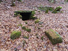
The desert area can be reached via the road connecting Hazlov and Vojtanov. At the end of Hazlov, a side street branches off to the north. The area is on the edge of the forest and is overgrown by trees. Some of the buildings stood up to the edge of a steep incision. Various overgrown remains of the foundation, stones lying around and a watering hole in the valley of the Vonsov brook can be seen. The remains indicate houses made of rubble stones.
history
The place was named in a document from Friedrich von Haslau in 1224 . The Ascher judge Kaspar Brusche, mayor of Eger from 1659 to 1670, bought the place for 1200 guilders. Otov belonged from 1869 to 1930 to the place Rommersreuth (Výhledy) in the district of Asch , then to the district of Asch and then until today to Hazlov in the Okres Cheb . The place last had 14 houses. The residents lived from agriculture or worked in the local quarry, whose stones were delivered to Eger, and others. a. for the construction of the Eger-Asch railway bridge.
Development of the population
|
|
|
Web links
Individual evidence
- ↑ http://www.uir.cz/katastralni-uzemi/638153/Otov-u-Hazlova
- ↑ Historický lexikon obcí České republiky - 1869-2015. Český statistický úřad, December 18, 2015, accessed on February 6, 2016 (Czech).
Coordinates: 50 ° 10 ′ N , 12 ° 17 ′ E


