Öxi
| Öxi | |||
|---|---|---|---|
|
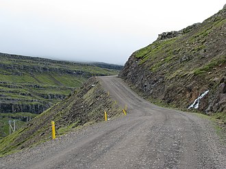
On the Öxi pass |
|||
| Compass direction | north | south | |
| Pass height | 532 m | ||
| region | Austurland , Iceland | ||
| Valley locations | Breiðdalsheiði | Professionjörður | |
| expansion | Pass road | ||
| Map (Austurland) | |||
|
|
|||
| Coordinates | 64 ° 51 ′ 9 ″ N , 14 ° 40 ′ 10 ″ W | ||
The Öxi - Pass is located in the southeast of Iceland and has a peak altitude of 532 m .
It shortens the route between Egilsstaðir and Höfn by 67 km compared to the ring road . The 20.71 km long Axarvegur leads over this pass ![]() . Its southern end is in Berufjörður . Before the expansion, this path was just a runway with five fords , which shortened the route but took more time than the detour via the ring road.
. Its southern end is in Berufjörður . Before the expansion, this path was just a runway with five fords , which shortened the route but took more time than the detour via the ring road.
See also
Web links
Commons : Axarvegur - collection of images, videos and audio files
Individual evidence
- ↑ Brottfararstaður Egilsstaðir. Retrieved March 4, 2020 (Icelandic).
- ↑ Vegaskrá 2019 - kaflaskipt. Retrieved March 4, 2020 (Icelandic).

