Oyashio
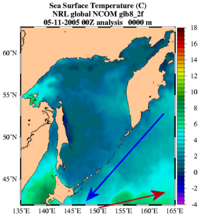
The Oyashio ( Japanese親 潮parent stream ) is a cold surface ocean current that flows in a south-westerly direction past the Kamchatka Peninsula and the Kuril Islands and meets the Kuroshio foothills to the east of Japan . Part of the colder and less salty Oyashio sinks under the Kuroshio and flows further south. The other part of the Oyashio forms on the surface together with the Kuroshio foothills the North Pacific Current (North Pacific west wind drift ).
The area where the two ocean currents meet around the Aleutian Islands is characterized by the frequent occurrence of fog banks . They arise when the relatively warm and therefore moist air above the Kuroshio, which is more than 20 ° C warm, is cooled by the cold water of the Oyashio. The air can then no longer store as much water, the excess moisture condenses in the form of fog.
The Oyashio transports an average of 15 million cubic meters of water per second, making it weaker than the Kuroshio. The flow strength is subject to cyclical fluctuations. In winter and spring the current is stronger with 20-30 Sverdrup (Sv), whereas in summer and autumn it drops sharply (only 3 - 4 Sv).
The Oyashio is the continuation of the Kamchatka Current , but after flowing through the Sea of Okhotsk it is renamed due to changed water properties and treated as a new current.
The Oyashio is fed by the cold up-flowing deep water of the polar region and is therefore very rich in nutrients. This fact led to its Japanese name: oya (parents), shio (current).


