
Pürgschachen Moor
| Pürgschachen Moor | |||
|---|---|---|---|
 |
|||
|
|||
| Location: | Styria , Austria | ||
| Next city: | Liezen | ||
| Surface: | 62 ha | ||
| Address: | 8904 Ardning 13 | ||

The Pürgschachen-Moor , also called Pürgschachener Moor and Pürgschachenmoos , is a moor area in Ardning , Styria, in the floodplains of the central Enns in Upper Styria .
It was included in the catalog of internationally important wetlands worthy of protection according to the Ramsar Convention on September 9, 1991 (No. 532, 62 ha).
It is also located in the area proposed as Pürgschachen moss and areas close to the Rennes between Selzthal and the Gesäuse entrance (AT2205000, 1,619 ha) on the EU list as Natura 2000 area according to FFH and bird protection guidelines ( pSCI status), as well as in the Ennstal landscape protection area from Ardning to Pruggern (LSG-43, 4,936 ha). An integration of the entire shelter into the Gesäuse National Park is also planned.
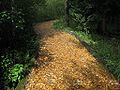
A moor hiking trail was opened in 2005. The moor can be hiked around in about 1 1/2 hours.

Moor nature trail, Ennssteg - a short footbridge about 2 m above the water of the Enns
Pürgschachen-Moor educational trail
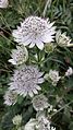
Carinthian large star umbel


Web links
- official website
- Ramsar area , State of Styria
- Pürgschachen Moor. In: UMWELTnet> Nature & Species Protection> Wetlands (Ramsar)> Ramsar areas. Federal Ministry of Agriculture, Forestry, Environment and Water Management (BMLFUW), accessed on June 27, 2010 .
Individual evidence
- ↑ Natura 2000 - Pürgschachen-Moos and areas close to the Rennes between Selzthal and the entrance to the Gesaeuse. (No longer available online.) In: verwaltung.steiermark.at…> A13 environmental, plant, building and spatial planning law> FA13C nature conservation> NATURA 2000> Natura 2000 areas-Styria. State of Styria - Office of the Styrian Provincial Government, archived from the original on February 8, 2006 ; Retrieved June 27, 2010 . Info: The archive link was inserted automatically and has not yet been checked. Please check the original and archive link according to the instructions and then remove this notice.
- ↑ LSG-43 Ennstal from Ardning to Pruggern. (No longer available online.) In: verwaltung.steiermark.at…> A13-Environment, Plant, Building and Regional Planning Law> FA13C-Naturschutz> Steir. Protected areas> Landscape protection areas. State of Styria - Office of the Styrian Provincial Government, archived from the original on February 8, 2006 ; Retrieved June 27, 2010 . Info: The archive link was inserted automatically and has not yet been checked. Please check the original and archive link according to the instructions and then remove this notice.