Papago Park
Papago Park is an urban park between the cities of Tempe , Scottsdale, and the eastern outskirts of Phoenix , Arizona . 486 hectares (1200 acre ) belong to the City of Phoenix and 120 hectares (296 acre ) belong to the City of Tempe, the portion of which is officially called Tempe Papago Park .
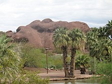
Papago Park is a hilly desert park known in the area for its eye-catching geological formations and home to some typical desert plants, including the giant cactus Carnegiea gigantea . The park grounds include a Desert Botanical Garden , the Phoenix Zoo, picnic areas, several small man-made lakes, hiking trails, bike paths, a fire museum, and Hunt's Tomb , a pyramid-shaped burial site that belonged to the first Arizona governor, George WP Hunt , initially built for his late wife, next to whom he was then also buried himself. In Tempe Papago Park there are also baseball and softball courts, on the border between the two parts of the park there is also a golf course, Rolling Hills Golf Course .
The area of the park overlaps in parts with the former POW camp of the Second World War, Camp Papago Park , which was partly built over with residential houses, partly still serves as military area of the Arizona Army National Guard .
literature
- Charles Liu: 60 Hikes Within 60 Miles: Phoenix: Including Tempe, Scottsdale, and Glendale. Menasha Ridge Press, 2010. pp. 44-47. ISBN 978-0-8973-2809-8 .
Web links
Coordinates: 33 ° 28 ′ 14.5 " N , 111 ° 56 ′ 57" W.


