Paper mill (Calbe)
The paper mill in Calbe (Saale) consists of several buildings, most of which were built in the 19th century, to the left and right of the mill canal in Calbe. These buildings and their predecessors served as a grain and sawmill from the 12th century and, from 1834, also as a paper mill . Today there is a turbine for power generation here.
geography
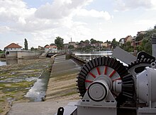
The Saale, the weir and the buildings of the old mill are located directly behind the houses on the east side of the market square of Calbe. A street leads about 50 meters from the market square directly to the weir that derives the Mühlgraben from the Saale. From the weir and from the island behind it you have a good view of the facilities.
The Saale is artificially split into three arms near Calbe. The easternmost arm is the Calbe lock ditch. It is used for shipping and contains the Divine Grace lock . The middle arm is the actual hall, which is dammed by a 152 meter long weir. This weir ensures the necessary water level in the lock. It also branches off the third, westernmost arm of the river, the Mühlgraben, which used to be a port. In the Mühlgraben there is a hydroelectric power station for generating electricity.
history
The first mills appeared in Calbe in the 12th century. The Saale formed an important trade route from north to south and thus promoted the development of the city of Calbe. The first wooden locks were built in Calbe in 1366.
In 1503, with the help of the residents of Calbe, a weir - the so-called dam - was built in the Saale. The Mühlgraben, which branched off at the weir, formed a harbor in which 113 merchant ships moored from 1556 to 1559. These ships mainly brought firewood for the Staßfurt salt works. This dock existed as a wood and coal yard until the 20th century.
After the wooden locks were renewed several times, the first stone lock was built in 1694–97. In the 18th century the navigability of the Saale was improved by the construction of further locks near Calbe.
In 1834 the merchant Brückner acquired the old mill. He modernized the flour mill. In addition, he built a paper factory, where he used the water power to knead the cellulose and to produce handmade paper.
In the revolution of 1848 the mill workers from Calbe fought on the side of the revolutionaries against the vigilante group.
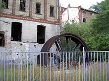
In 1870 the current 152 meter long defensive wall was built. The water wheels were replaced by turbines and electricity was generated. One of the old flywheels with a diameter of 5 meters is exhibited to the side of the building.
In the days of the popular uprising of June 17, 1953 , workers in the paper mill protested against the poor living conditions in the GDR. Some of them have been arrested for incitement to the state .
In 1956 the defensive wall was increased. At the weir there was a system with 26 movable defense boards, via which the upper water at the Gottesgnaden lock was regulated by the lock master.
In 1968 a hydraulic roof weir was installed, which was 78 centimeters higher than the old weir. Today (2014) there is a hydroelectric power station in the old mill.
The buildings of the old paper mill in Calbe are under monument protection. Unfortunately, they have been the victims of arson attacks over and over again in recent years and look somewhat ruinous.
literature
- Dieter Horst Steinmetz: From the royal court Caluo 936 to the district town Calbe 1919 - history of a central German town. From the beginning to the establishment of the Weimar Republic. Magdeburg / Calbe / Saale 2010
- http://journal.lhbsa.de/cpt-articles/muehlenland-sachsen-anhalt-teil-10-der-ueber-tausend-jahre-alte-muehlenstandort-calbe-saale/
Web links
swell
- ↑ http://www.17juni53.de/karte/magdeburg/schwachenwalde.html
- ↑ http://www.blaues-band.de/saale/index.htm?calbe.htm
- ↑ Dieter Horst Steinmetz: Brief outline of the history of the city of Calbe on the Saale. http://www.calbe.de/upload/dokumente/publikationen/tourismus/geschichte_1075.pdf
- ↑ Archived copy ( Memento of the original from July 28, 2014 in the Internet Archive ) Info: The archive link was automatically inserted and not yet checked. Please check the original and archive link according to the instructions and then remove this notice.
Coordinates: 51 ° 54 ′ 13.6 " N , 11 ° 46 ′ 39.1" E


