Paulínia
|
|||
| Country | São Paulo | ||
| surface | 139 km² | ||
| Population population density |
82,146 (IBGE / 2010) 592 / km² |
||
| height | 590 m | ||
| width | 22 ° 45'40 "S | ||
| length | 47 ° 09'15 "E | ||
| Distance to São Paulo | 118 km | ||
| Post Code | 13140-000 | ||
| City administration | Prefeitura Municipal de Paulínia - Av. José Lozano Araújo, 1 515, Parque Brasil 500 | ||
| Internet | http://www.paulinia.sp.gov.br/ | ||
| mayor | Dixon Carvalho | ||
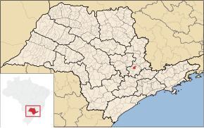
| Location in São Paulo | |||
|---|---|---|---|
Paulínia , officially Município de Paulínia , is a city in the Brazilian state of São Paulo .
Geography and demography
In 2018, an estimated 106,776 people lived in Paulínia on 139 km². Paulinia is located about 118 kilometers from São Paulo. In the north of the city there are large chemical and petrochemical plants such as Replan (Refinaria do Planalto Paulista) with a crude oil processing capacity of around 18 million tons per year and a Rhodia plant . Thanks to the high level of industrialization , the city has the seventh highest per capita income in Brazil. The city is traversed by two rivers , the Rio Jaguari , which flows past the edge of the city, and the Rio Atibaia , which flows through the city in the center and divides it in half.
etymology
The town was named Paulínia in honor of the farmer José Paulino Nogueira , one of the owners of the Fazenda do Funil , which was between Paulínia and Cosmópolis. The village that gave the city its name was called Vila José Paulino until 1944 . However, a law from that year forbade naming locations after living people. The village was therefore renamed Paulínia.
history
The story of Paulínia begins with the assignment of two great sesmarias on the territory of the present city. The sesmarias system, originally introduced in Portugal at the end of the fourteenth century to optimize the cultivation of the land, was used in Brazil to regulate settlement. In 1807 the Sesmaria Morro Azul was awarded, on which the Faziendas Bento and Funil were founded.
Recent history is characterized by a great economic boom and a great population growth. In the 1980s the city hospital was built. At that time the city had 20,753 inhabitants. In the 1990s, the Sambódromo de Paulinia was built and the road network expanded.
Personalities
- Marcela Temer (* 1983), politician
climate
Paulínia has a tropical mountain climate with average temperatures. The rainfall is above average.
Larger neighboring cities
economy
Boehringer Ingelheim opened a new manufacturing facility for veterinary drugs in 2017.
Web links
- City Prefecture website (Portuguese)
- Câmara Municipal website (Portuguese)
- A report by Adrian Lobe in the Austrian daily Standard from December 30, 2010
Individual evidence
- ↑ IBGE to Paulínia. Retrieved June 2, 2019 .
- ↑ The Sesmarias In Brazil: Colonial Land Policies In The Late Eighteenth-Century (PDF; 290 kB) www.brown.edu. Retrieved April 5, 2009.
- ↑ Associação Brasileira de Marketing Rural e Agronegócio (AMBRA): Boehringer Ingelheim Saúde Animal inaugura a mais moderna fábrica de vacinas contra Febre Aftosa da América Latina. Date: May 30, 2017. Retrieved July 10, 2017 (Portuguese).
Coordinates: 22 ° 46 ′ S , 47 ° 9 ′ W


