Pfaffenberg (Hohenstein-Ernstthal)
| Pfaffenberg | ||
|---|---|---|
|
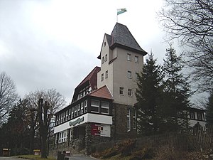
Mountain inn on the Pfaffenberg |
||
| height | 479 m | |
| location | near Hohenstein-Ernstthal | |
| Mountains | Erzgebirge foothills | |
| Coordinates | 50 ° 48 '42 " N , 12 ° 43' 23" E | |
|
|
||
The Pfaffenberg is a 479 m high mountain in the area of the Saxon town of Hohenstein-Ernstthal ( district of Zwickau ) in the northern Erzgebirge foreland .
description
As station no. 16 Pfaffenberg , the mountain was a first-order station of the royal Saxon triangulation in the 1860s . For this reason, a surveying column was erected on the summit, which has been preserved to the present day. In good weather conditions, the view of the highest mountain in Saxony, the Fichtelberg , is tremendous. The large area offers a variety of opportunities for walkers and hikers. In the center of the area is the mountain inn built in 1911 by the Erzgebirgsverein , which is unfortunately currently closed. There is also a dendrological nature trail, a large variety of rhododendrons, and an open-air stage with seating for concerts or events in the area. The Pfaffenberg also offers 2 playgrounds for children. The first mountain festival also took place in 1911.
The Pfaffenberg belongs to the Pfaffenberg – Oberwald nature reserve .
Trivia
- The orchestra "Die Pfaffenberger", located in Hohenstein-Ernstthal and belonging to the association "Jugendblasorchester Hohenstein-Ernstthal eV", is named after the Pfaffenberg.


