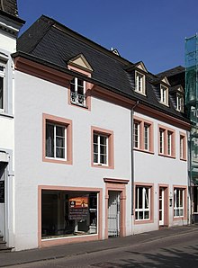
Horse market (Trier)
The horse market is a place in Trier that is located to the north of the Mitte district .
location
Today the square is an important traffic junction, especially as the intersection of seven star-shaped streets leading to the square. The following streets converge on the square (from north to south in a clockwise direction):
- Bruchhausenstrasse
- Kutzbachstrasse
- Moselstrasse
- Jakobstrasse
- Walramsneustraße
- Oerenstrasse
- Deutschherrenstrasse
history
The horse market is the city's medieval stacks . The place has been proven as a platea Staffela since 1271 . From the 13th century onwards the square was called “am Staffel” and from the 17th century it was called “Horse Market”. As such, however, it was only used until the 18th century .
The sewer, attested from 1250 onwards, ran across the square from Jakobstrasse to Gasse An der Sug (now Bruchhausenstrasse), which was also known as Spülbach from 1460 , to the city moat.
shops
There are several shops around the square and the Treviris-Passage shopping mall is right next to the horse market. The Cinemaxx cinema is located on Moselstrasse . The Trier pedestrian zone is also within walking distance.
Cultural monuments
There are three cultural monuments at the horse market . Among the buildings, the semi-detached house at Horse Market 7 stands out in particular. It is characterized by its architectural and furnishing elements from the 17th to 20th centuries , which can be found on both halves of the house, which have been molded several times over. Fighter and lintel under the skylight are adorned with a cross-arch frieze. The beam-like stripe under the roof shows the construction date and the house numbering 18 -No. 305- 20. On the second house on the ground floor a richly stuccoed beamed ceiling of the 17th century (so-called Cologne ceiling), a late Baroque, by pilasters with Rocaille - capitals flanked oven niche and upstairs a simpler oven niche, probably the latter from the early 19th Century .
At the confluence with Walramsneustraße was the baroque Cistercian convent of St. Anna, which was largely demolished in 1812.
literature
- Patrick Ostermann (arrangement): Cultural monuments in Rhineland-Palatinate. Monument topography Federal Republic of Germany. Volume 17.1: City of Trier. Old town. Werner, Worms 2001, ISBN 3-88462-171-8
- Ulrike Weber (edit.): Cultural monuments in Rhineland-Palatinate. Monument topography Federal Republic of Germany. Volume 17.2: City of Trier. City expansion and districts. Werner, Worms 2009, ISBN 978-3-88462-275-9 .
- General Directorate for Cultural Heritage Rhineland-Palatinate (publisher): Informational directory of cultural monuments of the district-free city of Trier. (PDF; 1.2 MB) Koblenz 2010.
- Kulturbüro der Stadt Trier (ed.) / Emil Zenz: Street names of the city of Trier: their sense and their meaning. Trier 2003.
Individual evidence
- ↑ Kulturbüro der Stadt Trier (ed.) / Emil Zenz: Street names of the city of Trier: their sense and their meaning. Trier, 2003.
- ↑ a b c d Monument topography Federal Republic of Germany. Cultural monuments in Rhineland-Palatinate. Volume 17.1 City of Trier - Old Town. Wernersche Verlagsgesellschaft mbH, Worms. ISBN 3-88462-171-8 (1st edition 2001)
Coordinates: 49 ° 45 ′ 33.3 " N , 6 ° 38 ′ 21.2" E


