
Pießling origin
| Pießling origin | ||||
|---|---|---|---|---|
 Pießling origin |
||||
| location | ||||
| Country or region | District of Kirchdorf an der Krems , Upper Austria | |||
| Coordinates | 47 ° 41 ′ 34 " N , 14 ° 16 ′ 34" E | |||
| height | approx. 750 m above sea level A. | |||
|
||||
| geology | ||||
| Mountains | Eastern Alps | |||
| Source type | Karst spring | |||
| Exit type | Source pot | |||
| rock | limestone | |||
| Hydrology | ||||
| River system | Danube | |||
| Receiving waters | Pießling → Teichl → Steyr → Enns → Danube → Black Sea | |||
| Bulk | 2200 l / s | |||
| depth | 32 m | |||

Coordinates: 47 ° 41 ′ 34 " N , 14 ° 16 ′ 34" E
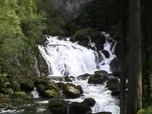
The Pießling-Ursprung is one of the strongest karst springs in Austria, which could cover the water needs of some 100,000 people on summer days. It is located in the municipality of Roßleithen near Windischgarsten in the south of Upper Austria . The Pießling origin was declared a natural monument in 1978 .
Data
On average, around 2,200 liters of water emerge from the spring every second. When the snow melts or when there are strong floods, it can be up to 40,000 liters per second. The source is fed by an underground drainage system made up of widely ramified cavities and collecting veins. The water comes from the Warscheneck , where it seeps into the limestone over an area of around 95 km² and flows underground to the source. The Pießling , which rises at the source, flows into the Teichl after about seven kilometers .
description
The blue-green spring pot at the entrance to the cave is 32 meters deep. The subsequent underwater passage was explored to a depth of approximately 80 meters. Behind the source pot there are also extensive air-filled corridors and halls, at the end of which there is another siphon lake . This siphon has so far been researched and measured over a length of 120 meters at a depth of 40 meters. So far, a total of around 1,500 meters of the extensive cave system has been explored.
First dives were made in 1962. Due to a diving accident in 1987 in which a diver and a gendarme who were used to rescue her were killed, diving in the spring pot is currently prohibited.
A river section with a steep gradient connects to the source pot. There are several partially restored mills, hammer mills and the Roßleithen scythe factory.
See also
literature
- Gerald Radinger: Hiking experience in the Kalkalpen National Park. The most beautiful tours between Enns and Steyr. Kral Verlag, 2012, ISBN 978-3-99024-066-3
Web links
Individual evidence
- ^ Province of Upper Austria: Nature Conservation Database
- ↑ Federal Ministry of Agriculture, Forestry, Environment and Water Management (ed.): Hydrographisches Jahrbuch von Österreich 2010. 118th volume. Vienna 2012, p. Q54, PDF (12.6 MB) on bmlrt.gv.at (2010 yearbook)