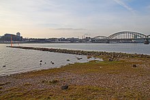
Bollard heads

The Bollard Heads are a historical bank fortification on the right bank of the Rhine opposite Cologne .
history
Since the High Middle Ages , the people of Cologne had observed with concern that after several breakthroughs on the right bank of the Rhine from Poll to Mülheim , the Rhine could look for a new river bed . Floods and ice drifts favored these changes. There was a danger that between Poll and Deutz there could be a permanent eastern breakthrough of the Rhine - flowing around Deutz to the east and returning to the old river bed in Mülheim - which would have cut off Cologne and especially its port facilities from the river. The Cologne council then had the unprotected bank at Poller Wiesen, which was the property of the archbishop , fortified with dams at its own expense. A contract with Archbishop Friedrich III. von Saar Werden allowed the people of Cologne to regulate the course of the river at the beginning of the 15th century, including the two Rhine islands Poller Werth and Osterwerth.
In 1479 the contract was canceled due to disputes between the council and the archbishop, the fortifications were then destroyed by the Duke of Berg . It was not until 1557 that the Cologne council and Archbishop Anton von Schaumburg could agree that Cologne would lease the Poller Ufer and fortify it again. In 1560 the major project was tackled, which was continued for over 250 years. A total of three heavy bank reinforcements ("heads") were created. In addition to hundreds of ships laid on the ground and filled with gravel, willow plantings and groynes were introduced to prevent deviations in the course of the river. Weighted down with lumps of basalt , iron-reinforced oak trunks - connected by heavy cross beams - were driven into the river bed.
In 1582, the Cologne councilor Hermann von Weinsberg noted in his notes that the head of the Poller Werth reached a long way to the Osterwerth with thick oaks and crowds, but not everything was clad with oak planks. A lot of work has been done and a delicious gem is being created for the city of Cologne to keep the Rhine in its bed. The northern head is said to have had a length of 1,500 meters. The fortifications protruded up to 3.5 meters above the water level. The supervision of the fortifications was given to a municipal willow keeper who had his house on the Oberwerth. In 1641 a stone weir replaced the piles. The heavy flood in February 1784 almost completely destroyed the facility.
The protective systems of the “Poller Heads” on the Poller Wiesen were replaced with modern fortifications and groynes with the construction of the Deutz harbor . In 2003 two of the ships laid to the ground for the bank reinforcement of the bollard heads were found during dredging work at the southern end of the bollard heads. T. archaeologically secured. These were 12 to 15 meters long, so-called "Dutch" built in 1530 and 1590. In 2005, the Poller Wiesen was placed under protection as a historical site on the right bank of the Rhine.
Individual evidence
- ↑ a b Pohl / Possible: Cologne on the right bank of the Rhine. , P. 193
- ^ The autobiographical notes of Hermann Weinsberg - Digital Complete Edition Liber Senectutis , 23 August 1582
- ↑ Low water makes it possible - discovery on the banks of the Rhine in Cologne , in: Monuments online, ed. by German Foundation for Monument Protection, May 2006
literature
- Stefan Pohl / Georg Mölich: Cologne on the right bank of the Rhine: Its history from antiquity to the present. Winand Cologne 1994
Web links
- monumente-online.de - Low water makes it possible - Discovery on Cologne's banks of the Rhine
Coordinates: 50 ° 54 ′ 46.3 " N , 6 ° 58 ′ 48.5" E

