
Cologne harbor
The Cologne ports at Rhein include with a water area of 877,000 square meters and a land area of 1.307 covers an area of more than two square kilometers and are for the handling of goods. Hotel, passenger and management ships (passenger ships) use the jetties specified in an occupancy plan . Cumulatively, the ports of Cologne are in second place in terms of cargo handling after the port of Duisburg and make Cologne the second largest inland port in Germany alongside the port of Hamburg . In contrast to Duisburg, the Cologne ports use several locations.
The Cologne ports are the oldest ports on the Rhine, they were built during Roman times .
Roman times
During excavations for the construction of a new line of the Cologne light rail, a Roman port gate and other remains from the period after 150 AD were found at Kurt-Hackenberg-Platz (Altstadt-Nord) in April 2008 at a depth of 13 meters that the gates on the Cologne harbor front - for obviously well-considered static reasons - did not extend beyond the city wall axis of the Rheinaue. The tower in the wall served to secure the gate; The two-winged 2.7 meter wide wooden gate opened on the one hand to the quays in the harbor, on the other hand it was connected to the Roman basalt-paved port road - now laid out at the Roman-Germanic Museum . It flowed into the Cardo maximus. In relation to the approximately 8 meter high city wall, a height of approximately 13.5 meters can be assumed for the port gate. Investigations by the University of Cologne on more than 150 oak piles found on the plank wall show a uniform felling campaign for the year 89 AD. The Rhine-side city wall was therefore built together with the port gate and the canal outlet in the last decade of the 1st century AD.
- First century of Cologne's Roman era

Excavation of the harbor gate at Kurt-Hackenberg-Platz in 2008

Fully preserved Roman transport amphora
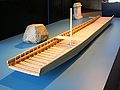
Reconstruction based on parts of a 1st century transport ship recovered in 2007 at a depth of 13 m (Alter Markt)

Stone relief recovered on the banks of the Rhine in Cologne, stern of the ship with helmsman and helmsmen
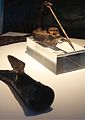
Boat hook recovered from under the old market (Roman port) and A fisherman's lamp


_aus_dem_r%C3%B6mischen_Hafen.JPG)
The Roman port gate at Kurt-Hackenberg-Platz is currently the only one of a total of nine city wall gates that is accessible as a stationary architecture. A shipwreck ( Prahm ) discovered under the Alter Markt can be dated to around 43 AD. Since it comes from the bottom of the old channel, it occupies a port in this area. By extending the arm of the Rhine to the east, the Romans succeeded in securing the stretch of water sufficiently as a port and in using a water surface of around 60,000 m² as a landing stage for 200 ships. The expanded port extended roughly from today's Breslauer Platz to the Holzmarkt, where the arm of the Rhine reunited with the main river.
Excavations between the Alter Markt and Bechergasse suggest that the Roman port imported wine, oil, fish sauce and other foods from the Mediterranean region to Cologne. Wines from southern Spain, southern France, Italy, Crete and the coast of Asia Minor can be detected. Olive oils came from Spain and North Africa, seasoning sauces from Spain and southern Italy. Oysters came to Cologne from Normandy . These foods were transported in amphorae . The Roman port had been located on a 60–70 meter wide arm of the Rhine from about 50 AD, which was separated from the main stream by an island up to 180 meters wide and over a kilometer long. It was located between Groß St. Martin and today's Kurt-Hackenberg-Platz on the Domplatte . After an extremely dry period around 150 AD, the harbor basin silted up and had to be abandoned.
middle Ages

In the Middle Ages ships used Cologne's bank fortifications as ports. Archbishop Anno II wanted, according to a description by Lampert von Hersfeld , to organize an opportunity to go home for his friend Friedrich I on June 23, 1074, for this purpose he arbitrarily had a ship confiscated in Cologne harbor and ordered the ship owner to remove the loaded goods and the ship prepare for the bishop's ride. The ship owner successfully resisted and was able to win over a crowd of angry citizens who threatened Anno II. He escaped unnoticed by escaping on June 23, 1074 in the Annostollen that had just been built and left the city in the direction of Neuss .
The function of the Cologne ports as a cargo handling metropolis made the city the most important Rhine port. Due to the flow conditions at the transition between the Middle and Lower Rhine , the so-called Dutch sailed the Lower Rhine to the north of the church of Groß St. Martin, while the Oberlanders traveled south of Cologne. At the level of Salzgasse and Groß St. Martin, a wooden frame marked the limit for these types of ships; this was also the port of transshipment from one ship to another. Anton Woensam immortalized Dutch Aaken grains in his 1531 view of the city of Cologne . They left the Cologne port and returned with colonial goods such as coffee, tea, rice, tobacco, sugar and spices.
Archbishop Konrad von Hochstaden ordered the introduction of stacking rights on May 7, 1259 because of the intensive freight traffic on the Rhine . According to this, the captains were obliged to initially offer all goods for three days to the citizens of Cologne, which was equivalent to a right of first refusal . Unsold goods were subjected to a quality control, taxed and then given the seal of the city of Cologne. These "Cologne goods" developed into an internationally recognized seal of quality. For example, the "Kölner Brand" guaranteed that the green herrings handled in Cologne - a staple food - met certain quality requirements. Some skippers circumvented this stacking right and unloaded their ships in the former Rhine island of Groov , south of Cologne , in order to transport their goods from there on the right bank of the Rhine to Cologne-Mülheim - still independent of Cologne - where they were shipped again. The stacking right undoubtedly established the economic boom of the city and the citizens of Cologne. It lasted almost 600 years until March 1831 when the Rhine Navigation Act came into force.
The largest medieval port at Groß St. Martin employed around 200 people, as well as those involved in towing . As early as 1380 there were four harbor cranes in Cologne, three of which were floating cranes at Rheingasse and Neugasse, a land crane on Markmannsgasse and a hoist on Mühlengasse. The harbor master, who assigns the anchorages, collects the harbor and crane fees and is responsible for maintaining the quays and the fairway, supervises the port activities. The goods are unloaded at the following bank locations:
- Between Witschgasse and Salzgasse: wine, building materials, bricks, building blocks and wood
- between Mühlengasse and Salzgasse: salt, fish, butter, cheese, bacon
- between Neugasse and Trankgasse: bricks and wood
The coal arrives at the Salzgasse Gate , where wine barrels are to be presented to the wine trade master .
On September 18, 1505, King Maximilian I confirmed the stacking right in full.
Founding period

An extreme flood with drift ice devastated on 27./28. February 1784 with a high water level of 13.55 meters large parts of Cologne's old town. The ice drift also destroyed the port facilities on the banks of the Rhine as well as the ships and cranes lying there. For this reason, the French administration allowed the construction of a free port at the Frankenwerft during the French period on June 11, 1802, which went into operation in April 1805. On April 2, 1811, the construction of a 500 meter long and 50 meter wide winter and security harbor ("Napoleonhafen") in the north of the old town begins at the point between Ebertplatz and Bastei , for which the first stone in the mouth was laid; it opened its doors in the winter of 1813. However, due to poor planning, the city architect Johann Peter Weyer temporarily completed the construction in 1829. After 1840 it increasingly silted up and was filled in in 1890. In 1970, excavations on Theodor-Heuss-Ring unearthed fragments of this port facility. In 1813, the Cologne port throughput fell to 500,000 quintals, while in 1789 it was still 1.5 million quintals.
The changeover from towing to steam shipping resulted in a major change in the flow of traffic on the Rhine. After the English steamship "Defiance" ("The Challenge") from James Watt reached Cologne on June 12, 1816 , the city administration pushed the considerations for the construction of a new port. The Rhine Shipping Act of March 31, 1831 also opened the Rhine to international shipping, making it the busiest waterway in Europe.

The Rheininsel Werthchen was to play the central role in the planning of a new Cologne port. Construction work on Werthchen began in 1847 and led to the closure of the southern river passage. In 1848 Johann Anton Wallé designed the construction of a security port on Werthchen. The newly created harbor basin, which is only accessible from the north, was completely enclosed by shipyard walls. On November 5, 1885, the Cologne City Council decided on the Rheinauhafen basin as the location for a new, enlarged port. On July 3, 1891, the council decided to build the port on the basis of Josef Stübben's overall plan and approved almost 20 million marks for this. Construction work on the “New Port and Shipyard in Cologne” began in the spring of 1892 with earthworks, and on May 14, 1898, the inauguration of the new Rheinauhafen took place. It received a siding with 18 km of track and 96 points and had the most modern technical port facilities in Germany.
Parallel to the Rheinauhafen, shipyards were built for the 350-meter-long Trankgassen shipyard in 1846, expanded in 1889, a special pumping station was built for this purpose and the shipyard was connected to the railway network in 1893. In 1886, 4859 loaded ships with 4,656,561 quintals called at the Cologne port, 3190 loaded ships with 2,626,841 quintals left it. In addition, 138,742 quintals were moved downhill as rafts.
Modern times
With the incorporation of Cologne-Deutz (April 1, 1888), Cologne-Mülheim (April 1, 1914) and Godorf (January 1, 1975), Cologne gained the ports of Mülheim, Deutz and Godorf. As a result of the expansion of the northern port of Niehl I into a commercial and industrial port, the Rheinauhafen lost its importance in 1970 and has been a marina since then . With the incorporation of Cologne-Porz in January 1975, the former pioneer harbor in Westhovener Aue and the marina at Groov in Cologne-Zündorf were added.
The individual ports
Today Cologne has five ports that belong to Häfen und Güterverkehr Köln AG (HGK). The HGK, founded on August 1, 1992, is the owner of all ports and the Rheinauhafen (exception: Mülheim), and it organizes and monitors port activities. Without Rheinauhafen, the water area of all ports is 877,000 m² with a land area of 1.307 km², the quay length reaches 28 km. Each port has a specific focus.
Niehl I.

Port of Cologne-Niehl I - Container Terminal (February 2010)

Maintenance port Niehl I - TwinCruiser "Bellevue" (March 2011)

Maintenance port Niehl I from KD (March 2013)

_001.jpg)

Niehl I (Rhine km 695.8) is Cologne's largest port in terms of area, with a total area of 1,310,600 m² (472,700 m² of which is water or 26% of the total area) and the central logistics hub of northern Cologne. The port, which opened in 1925, now has four docks, and the two container terminals occupy more than 70,000 m². There are a total of 14 crane systems . It is also a maintenance port for passenger ships, especially the Cologne-Düsseldorf Deutsche Rheinschiffahrt (KD). From 1959 a steady expansion of the port began, which lasted until 1970. In 2011, around 2,220 ships with 2,093,700 tons of freight were loaded and unloaded in Niehl I.
Niehl II
Niehl II (Rhine km 699.1) handles the oil and gas handling and chemicals, Ford ships new cars here. The land area is 59,700 m², the water area 87,800 m² (59%). In 1958 the construction of the oil port began. With the closure of the Esso refinery in 1985, Niehl II lost its top-selling customer. The port company responded to this in the same year by setting up two roll on roll off systems (“RoRo”), which can load car transporters together with the cars manufactured by the nearby Ford plants . A pedestrian bridge (cable-stayed bridge) has been running across the port entrance since 1986. The port tonnage handled is 412,800 t (2011).
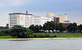
Cologne-Mülheim

Port of Cologne-Mülheim, in the background the customs tower from 1880 (around 1910)
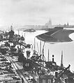
Port of Cologne-Mülheim (around 1913)

Cologne-Mülheim port from the air (July 2010)

Port of Cologne-Mülheim (May 2014)


.jpg)

The port of Mülheim on the right bank of the Rhine (Rhine km 691.5) was opened in 1880. Since the dismantling of the only heavy lift crane in May 2000, he has no longer handled any goods, but operates slipway systems for dangerous goods transport ships. The port of Mülheim will also be of considerable importance as a port facility in the future, particularly for increased use as a night berth and repair port. The shipyard Deutz GmbH & Co. KG maintains extensive facilities for the repair, modernization and conversion of cargo and passenger ships in the port of Mülheim. As the only port in Cologne's urban area, the port of Mülheim, including its water area (port basin), is part of the international waterway "Rhine", which is dedicated according to Section 1 of the Federal Waterways Act . Therefore the port belongs to the Federal Republic; the water and shipping office in Cologne , represented here with a branch office (the Tonhof waits for shipping signs), is the operator for the Federal Republic of Germany. The land area is 260,000 m², the water area 130,000 m² (50%). The port of Mülheim used to be used for bulk and general cargo handling, the largest customer was Felten & Guilleaume . The so-called "Katzenbuckel" pedestrian bridge made of prestressed concrete was built in 1955 for the 1957 Federal Garden Show .
Cologne-Deutz

Port of Deutz, painting by Friedrich Wilhelm Schreiner (1822)

Cologne-Deutz port from the air (August 2013)

Cologne-Deutz port (Ellmühle) from the air (August 2013)
Port of Cologne-Deutz - Ellmühle (August 2013)


The Deutzer Hafen (Rhine km 687.3), also on the right bank of the Rhine, was opened on December 14, 1907. He suggests m² on a land area of 240 700 and a water surface of 123,700 m (34%) from the grain adjacent to the Kampffmeyer mills belonging Ellmühle as well as feed liquid chalk and scrap to, the total tonnage is 264,500 t. The listed, electrically operated swing bridge opened in March 1908 and is a special feature at the entrance to the only port basin. In September 2009 the City Council of Cologne decided to examine a partial conversion of the port. In addition to its function as a grain port, the city has been planning since September 2013 to distribute the remaining port functions to other ports and to expand the port area that will become a residential, commercial and service center.
Cologne-Godorf

Godorfer Hafen - compressed air barrier (July 2014)

Godorfer Hafen - Liquid cargo extinguishing system (April 2010)


The port of Godorf is at km 671.9 on the Rhine. When the port was founded in 1901 as a transshipment facility for lignite, Godorf was not yet part of the city of Cologne. After the opening of the Vochem – Brühl – Wesseling railway on April 1, 1901, the shipyard between Godorf and Wesseling followed. In 1928, today's port basin I was added, and in 1960 the operating company opened basin II ("oil port") together with the Shell refinery. In 1961 the port basin III ("gas port") was completed. After the war, port activities resumed on September 1, 1945, and since then it has been handling chemical liquids and gases from neighboring factories ( Shell Rheinland Raffinerie , Rheinische Olefinwerke (today Lyondellbasell )), for whose tankers special devices such as liquid goods extinguishing systems are installed. It is Cologne's busiest port. Goods of the group “petroleum, petroleum products, gases” as well as various chemical products such as acids and alkalis are the most important of the goods groups handled there with 5 million t (84% of the total turnover). This is followed by salt (281,600 t), gravel (233,400 t) or moisture hydrate (203,600 t). The Godorf harbor has 170,200 m² of land and 192,900 m² of water (53%). As the only Cologne port, its water area is larger than the available land area. In 2011, a total of 3,310 ships with a tonnage of 5,919.2 million t were loaded and unloaded on four cranes and 17 systems for liquid or gaseous dangerous goods.
Rheinauhafen
The Rheinauhafen (Rhine km 686.2) has completely lost its port function except for the yacht harbor that has been located here since 1971 and is now a residential, cultural and office center.
meaning
The overall port concept adopted by the City of Cologne on March 3, 1988 aims to intensify two main ports (Niehl I and Godorf) as the basis for the economic development of the Cologne ports and assign the ports of Rheinau and Mülheim a "subordinate importance". The city of Cologne is the second largest inland port in Germany after Duisburg, but the largest German seaport, Hamburg , handled just as much inland waterway traffic in 2015 (12.4 million t). The port throughput of 12.4 million t (2011) for 7000 ships consists in particular of 4.8 million t of crude oil / gas / mineral oil products (38%), 4.1 million t of vehicles / machines (33%) and 1.8 million t of chemical products (14%). The sales revenues from this amounted to EUR 10.6 million. The Cologne ports show significant dependencies on some location-bound large providers with the risk of high handling losses if a large customer fails. That was the case with the move of the Esso refinery in Niehl in 1985 and the closure of the chemical factory in December 1993 (Deutz). Only eleven companies account for 80% of the total throughput in the ports. Although the Cologne ports are organizationally and operationally a unit, they act as individual ports thanks to their port facilities tailored to the individual needs of the economy. Inland shipping is still an important economic factor in the city, not least due to further expansion and the sometimes controversial modernization of Cologne's ports.
literature
- Carl Dietmar / Csaba Peter Rakoczy: Cologne, the Rhine, the sea. 2000 years of Cologne shipping and port history , Emons-Verlag, Cologne 2002.
- Werner Schäfke : Port of Cologne , Emons-Verlag, Cologne 2012, ISBN 9783954510016 .
- Josef Dollhoff: The Cologne Rhine Shipping . Bachem, Cologne 1980.
Web links
- Port city of Cologne Official website
Individual evidence
- ^ Fritz Voigt: Traffic: The development of the traffic system , 2nd volume, 1965, p. 344
- ^ Alfred Schäfer, Marcus Trier: Stadtarchäologie im Roman Köln , Ein Hafentor im Roman Köln, from November 5, 2012, p. 2 f.
- ^ Alfred Schäfer: Cologne: Roman port and Rhenish city fortifications. On the role of the Roman army as a developer , in: Heike Kennecke (Hrsg.): The Rhine as a European traffic axis . Die Römerzeit , Bonn Contributions to Pre- and Protohistoric Archeology, 16, 2014, pp. 117–143, here p. 118
- ^ Römisch-Germanisches Museum, Kölner Römer-Illustrierte , Volumes 1 and 2, 1974, p. 33
- ^ Matthias Riedel: Cologne - a Roman economic center , 1982, p. 110
- ↑ Dietrich Ohlig: DWhG - Ten Years of Water History Research and Reports , Part 1, 2012, p. 186
- ^ Lampert von Hersfeld: Annalen , 1973, p. 236 ff.
- ↑ Theodor Lindner: Anno II. The Holy Archbishop of Cologne: 1056-1075 , 1869, p. 85 f.
- ↑ flat-bottomed, 25 meter long and 4 meter wide cargo ships, called “Aar” or “Aaken” in Cologne
- ↑ large clinker ships with trapezoidal hulls, high stern and large rudders; 15 meters long, at the raised stern 6.5 meters wide, at the bow 3.5 meters, 8 meters high
- ^ Richard Deiss: As far as the rivers carry , 2011, p. 35.
- ↑ Dietrich Ohlig: DWhG - Ten Years of Water History Research and Reports , Part 1, 2012, p. 202
- ↑ The transport of goods overland was also later subject to stacking law.
- ^ Brigitte Corley: Painter and founder of the late Middle Ages in Cologne 1300-1500 , 2009, p. 12 f.
- ^ Carl Dietmar: Chronik Köln , 2006, pp. 87, 135.
- ↑ Richard Deiss, As far as the rivers carry , 2011, p. 36.
- ↑ Yvonne Leiverkus: Cologne: pictures of a late medieval city , 2005 S. 61st
- ↑ Yvonne Leiverkus, Cologne: pictures of a late medieval city ff, 2005 S. 97th
- ↑ a b Yvonne Leiverkus, Cologne: Pictures of a Late Medieval City , 2005, p. 99 f.
- ↑ Peter Fuchs (Ed.): Chronik zur Geschichte der Stadt Köln , Volume 2, 1991, p. 115.
- ↑ Peter Fuchs (Ed.), Chronicle of the History of the City of Cologne , Volume 2, 1991, p. 117.
- ↑ Horst-Johannes Tümmers: The Rhine: a European river and its history , 1999, p. 217.
- ^ Wilhelm Treue: Wirtschafts- und Technikgeschichte Preußens , 1984, p. 425.
- ↑ Europaverkehr, Volumes 21-22, 1973, p. 45.
- ↑ Peter Fuchs (Ed.): Chronicle of the History of the City of Cologne , Volume 2, 1991, p. 163.
- ↑ Otto Schneider: Cologne as a shipping location from the end of the 18th century to 1913 , 1928, p. 113.
- ^ Meyers Konversationslexikon Leipzig and Vienna, 4th ed. 1885-1892, IX p. 948.
- ^ Jürgen Wilhelm: The great Cologne Lexicon , 2008, p. 190
- ↑ Frank Binder: Hamburg has replaced Cologne · Hanseatic city is the second largest German inland shipping port . In: Daily port report of February 20, 2016, p. 3.
- ^ City of Cologne, Overall Port Concept , 1988, p. 120.
- ↑ Ports of the City of Cologne, 1967, p. 11