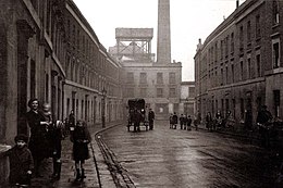
Portland Road
The Portland Road is a street in the London district of Notting Hill in the district of Kensington and Chelsea . The street, laid out in the 1850s , begins on Holland Park Avenue in the south and ends on Clarendon Road in the north .
history

The road has always been considered a border region between rich and poor. The English social researcher Charles Booth established at the end of the 19th century that Portland Road consists of two halves, the northern end of which is characterized by poverty and the southern section of which is relatively prosperous. Here, at different ends of the same street, lived the wealthiest and poorest five percent of London's population in the immediate vicinity. Nowhere in London, Booth continues, did two worlds collide with such power as here. But the social contrasts not only shaped the street itself, but also its immediate surroundings. To the east of Portland Road were the exclusive houses of the Ladbroke Estate of Notting Hill and to the west of it the remains of a slum , also known as the Notting Dale . According to Booth, there lived casual workers, street vendors, idlers, criminals and semi-criminals.
Booth described nearby Notting Dale as the worst part of London. Around 50 gypsy families settled in this area in 1862/63 and later penetrated as far as Portland Road, which shaped the future population structure for decades. Notting Dale was not only an ugly place, but the majority of its residents were considered criminal, which led Booth to the more frequently cited statement that the residents of this area were "more criminal than poor".
In the 1950s the area changed and Notting Dale was - despite its long-standing settlement by Gypsies and Irish migrants - a predominantly white and almost closed community, while many migrants from the West Indian region and Africa had settled in neighboring areas. In this racially explosive mixture, Portland Road was seen as a buffer zone between the two worlds.
By increasing gentrification in the 1960s and 1970s years, the reputation of the Portland Road improved, but prices remained at first still in the affordable framework. At that time, Julie's exclusive restaurant-bar was opened at number 135 on Portland Road , and it served the likes of The Beatles , The Rolling Stones and Roxy Music .
However, in recent years gentrification in the southern section of the road has led to a rapid rise in prices and a new population structure. The actors, playwrights and musicians living there could no longer afford the rapidly rising rents and had to give way to top bankers, financial analysts and tax evaders. In contrast, time seems to have stopped in the northern section. This is where the social housing (Winterbourne House and Nottingwood House) built in the 1930s is located , where brewery employees used to live. The average prices for residential property there are only around ten percent of the value to be paid in the southern section of the street.
Individual evidence
- ↑ Claudia Joseph (Daily Mail): Is this the UK's most divided street? (English; article from May 26th / May 28th 2012)
- ↑ Joseph Bullman, Neil Hegarty, Brian Hill: The Secret History of Our Streets - A Story of London . BBC Books, London, 2013, p. 239. ISBN 978-1-84990-451-3
- ↑ Joseph Bullman, Neil Hegarty, Brian Hill: The Secret History of Our Streets - A Story of London , p 242
- ↑ Joseph Bullman, Neil Hegarty, Brian Hill: The Secret History of Our Streets - A Story of London , p 240
- ↑ Joseph Bullman, Neil Hegarty, Brian Hill: The Secret History of Our Streets - A Story of London , p 248
- ↑ Joseph Bullman, Neil Hegarty, Brian Hill: The Secret History of Our Streets - A Story of London , p 252
- ↑ Joseph Bullman, Neil Hegarty, Brian Hill: The Secret History of Our Streets - A Story of London , p 254
- ↑ Joseph Bullman, Neil Hegarty, Brian Hill: The Secret History of Our Streets - A Story of London , p 247
- ↑ Joseph Bullman, Neil Hegarty, Brian Hill: The Secret History of Our Streets - A Story of London , p 272
- ↑ Joseph Bullman, Neil Hegarty, Brian Hill: The Secret History of Our Streets - A Story of London , pp. 274f
- ↑ Joseph Bullman, Neil Hegarty, Brian Hill: The Secret History of Our Streets - A Story of London , p 282f
- ↑ Joseph Bullman, Neil Hegarty, Brian Hill: The Secret History of Our Streets - A Story of London , p 284
- ↑ Keith Moore (BBC News): Is this UK's most gentrified street? (English; article from June 27, 2012)
Coordinates: 51 ° 30 '36.9 " N , 0 ° 12' 37.8" W.