Portocolom
| Felanitx municipality: Portocolom | ||
|---|---|---|
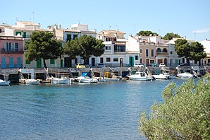
 Portocolom (historic harbor, boathouses)
|
||
| coat of arms | Map of Spain | |
 Help on coat of arms |
|
|
| Basic data | ||
| Autonomous Community : | Balearic Islands | |
| Island: | Mallorca | |
| Comarca : | Migjorn | |
| Coordinates | 39 ° 25 ′ N , 3 ° 15 ′ E | |
| Residents : | 4,586 (2011) INE | |
| Postal code : | 07670 | |
| Area code: | 07022000600 | |
Portocolom is a port on the east coast of the Spanish Balearic island of Mallorca . Portocolom belongs to the municipality of Felanitx . The place has 4586 inhabitants (as of 2011).
geography
The rocky coastline at Portocolom has a wide opening to a large natural bay that extends into the land in a semicircle and is surrounded by gently sloping terrain.
description
Portocolom is the largest natural harbor in Mallorca and therefore one of the most important fishing ports on the island. The historic center is in the eastern part of the bay on a flat knoll ( 14 msnm ). There you will find the historic port of Es Riuetó and the typical small houses of a fishing village with colorful doors and windows. Along the old pier are the traditional boat houses, the barraques , each equipped with a boat ramp and with equally brightly painted gate doors. Numerous small traditional boats, the llauts , are also moored at the old pier . Many consider this area to be one of the best preserved town centers in Mallorca. The place spreads from the east along the bay to the west.
A large part of the bay, the Badia de Portocolom , is used by the new port , the Porto de Portecolom , for fishing and by the large marina for private boats. There are numerous shops, restaurants and bars along the promenade.
In the west of Portocolom there is an urbanization characterized by modern hotels and apartments around the neighboring bay of Cala Marçal .
Attractions

The church Mare de Déu del Carme ( Mother of God of Mount Carmel ) is one of the few historical monuments in Portocolom.
The approx. 2 km long route that leads from the historic town center through a wide footpath and the street to the Far de Portocolom lighthouse is particularly appealing . The small s'Arenal beach is on the way.
Also of interest is the Closos de Can Gaià archaeological site from the Bronze Age.
Culture
The international Triathlon de Portocolom has been held annually in April since 1997.
beaches
- s'Arenal
- s'Algar
By spring 2020, a completely new stretch of beach had naturally formed in Portocolom within two years. According to experts, the dynamics of the sea, the rise in sea levels and the severe storms of the past are responsible for this. The sand is carried from one place to another and is deposited in a new place.
Bays
- Cala Marçal , 0.5 km away
- Cala Brafi , 2 km away
- Cala Estreta , 2.5 km away
Others
Portocolom claims to be the birthplace of the navigator Christopher Columbus . In particular, the name of the community ( colom ) reflects the name of the discoverer.
Web links
Individual evidence
- ↑ Anabel Ruiz: Se forma una nueva playa natural en Portocolom. Diario de Mallorca, March 29, 2020 (Spanish).


