
Puerto del Carmen
| Municipality of Tías: Puerto del Carmen | |||
|---|---|---|---|
 Playa de los Pocillos in the evening time
|
|||
| coat of arms | Map of the Canary Islands | ||
 Help on coat of arms |
|
||
| Basic data | |||
| Autonomous Community : | Canary Islands | ||
| Province : | Las Palmas | ||
| Island: | Lanzarote | ||
| Coordinates | 28 ° 55 ′ N , 13 ° 39 ′ W | ||
| Residents : | 11,387 (2011) INE | ||
| Postal code : | E-35510 | ||
| Area code: | 35028000700 | ||

Puerto del Carmen , a former fishing village, is located in the area of the municipality of Tías and is the most important and largest tourist destination on the Canary Island of Lanzarote .
geography
There are many apartment complexes and various hotels along the extensive beaches of Playa Blanca and Playa de los Pocillos, grouped under the name of Playa Grande, along the promenade for about eight kilometers. In the direction of Arrecife , Playa Matagorda joins. Puerto del Carmen can accommodate around 30,000 guests. Mainly Germans and British, followed by Scandinavians and Spaniards make up the audience.
The place has a continuous main structure over its entire length from the beach to the upward, undeveloped land. The sandy beaches of different widths are bordered by the beach road ( Avenida de las Playas ). Tourist life is concentrated on this street day and night, it is lined with bars, restaurants, boutiques, photo shops, supermarkets and amusement arcades.
The apartment complexes are located above Strandstrasse within a strip no more than a kilometer wide. Often there are self-contained facilities with their own swimming pool and bar. Badlands can be found further inland. It is characterized by land expected to be built, rubble ruins and agricultural wasteland.
This structure is interrupted by the old town center (Punta Tiñosa) in the port area.

Regular events
Every year in May, the Ironman Lanzarote (Ironman Lanzarote Canarias) has taken place here since 1992 - a triathlon sporting event over the Ironman distance (3.86 km swimming, 180.2 km cycling and 42.195 km running).
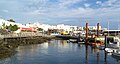
The old port, in the middle left the historic restaurant La Casa Roja

In the old port of Puerto del Carmen

View from the beach on the Avenida de las Playas

Typical night picture


