
Qualibou
| Qualibou | |
|---|---|
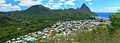
 View from Gros Piton |
|
| height | 777 m |
| location | Soufrière , St. Lucia |
| Coordinates | 13 ° 50 '17 " N , 61 ° 2' 46" W |
 Mountains on St. Lucia |
|
Qualibou (also: Soufrière Volcanic Center ) is a 3.5 × 5 km caldera on the island of Saint Lucia , which was formed around 32–39,000 years ago. This eruption created the Choiseul tuffs , which cover the southeast of the island.
The caldera is located in the area of the Pitons , a nature reserve in which the eponymous mountains are located, volcanic cores that were probably formed even earlier (200-300,000 years), long before the caldera was formed. And since then several other volcanic domes have filled the caldera. The last Phreatic explosion in 1766 ejected ashes that can be detected over a wide area.
In the center of the caldera is Sulfur Springs , a still active geothermal area.
In 1990, 1999 and 2000 there were several volcanic earthquakes in shallow depths 6 km east-south-east of the caldera.
gallery

Petit piton
Soufrière and the Pitons
