Río Aysén
|
Río Aisén Río Aysén |
||
|
Río Aisén in Puerto Aisén |
||
| Data | ||
| location | Región de Aysén ( Chile ) | |
| River system | Río Aisen | |
| confluence | from Río Mañihuales and Río Simpson 45 ° 24 ′ 43 ″ S , 72 ° 36 ′ 15 ″ W |
|
| muzzle |
Aisén Fjord coordinates: 45 ° 24 ′ 40 ″ S , 72 ° 49 ′ 0 ″ W 45 ° 24 ′ 40 ″ S , 72 ° 49 ′ 0 ″ W. |
|
| Mouth height |
0 m
|
|
| length | 26 km | |
| Catchment area | 11,427 km² | |
| Drain |
MQ |
628 m³ / s |
| Left tributaries | Río Blanco | |
| Right tributaries | Río Los Palos | |
| Small towns | Puerto Aisen | |
|
Location of the Río Aisén |
||
|
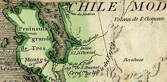
1775: The Río Aisén in Juan de la Cruz Cano y Olmedilla's map of South America was called Río Sinfondo ('Deep River') |
||
The Río Aisén , also Río Aysén , is a river in western Patagonia in the south of Chile .
It is created by the confluence of the Río Mañihuales and the Río Simpson . Over its total length of only 26 km it flows in a westerly direction, crossing the small town of Puerto Aisén , to its confluence with the Aisén Fjord . Its catchment area covers around 11,400 km² between the Chilean coast in the west and the border area with Argentina in the east. It arises from the confluence of its two source rivers, Río Mañihuales with 62 km length and Río Simpson with 88 km length. The main tributaries are the Río Blanco , 36 km long, and the Río Los Palos , 8 km long.
discovery
The existence of a large river was known as early as the 17th century, its mouth near the 45th parallel on the coast of Western Patagonia. It was first mentioned in literature in 1646 by the Jesuit Alonso de Ovalle under the name Río de los Rabudos ('River of the Long Tails '), named after the name the Spaniards gave to the indigenous people in the region. With this name, or a variant of the Río de los Barbudos ('River of the Bearded'), the river is shown in many maps from the 17th and 18th centuries.
In 1763 the Jesuit Vicuña came on a missionary trip to the Aisén Fjord and drove there for four days over the Río Aisén, as far as it was navigable with his small boat. His observations were included in the map for the travelogue of another mission trip that the Jesuit José García Alsué carried out in the southern summer of 1766/67. In this map, the Aisén Fjord is referred to as Estero Aysén , into which a river called the Río de los Desamparados ('River of the Defenseless') flows. At the time, it was believed to have its source at the foot of the San Clemente volcano . The inhabitants of this region were the Chonos , who lived in many small groups, mostly on the offshore islands. The Chonos called the region around the river Aisén .
Individual evidence
- ↑ Hans Steffen : Relación de un viaje de esploración al Río Aisén. Diciembre de 1896-mayo de 1897 por el Dr. Hans Steffen . In: Viajes de esploración i estudio en la Patagonia occidental 1892–1902 . tape 2 . Imprenta Cervantes, Santiago de Chile 1910, p. 74-180 ( memoriachilena.cl ).


