Río Tempisque
| Río Tempisque | ||
|
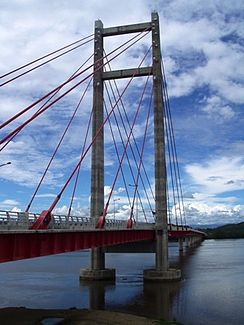
Bridge over the Río Tempisque |
||
| Data | ||
| location | Costa Rica | |
| River system | Río Tempisque | |
| muzzle |
Gulf of Nicoya ( Pacific ) Coordinates: 10 ° 11 ′ 35 " N , 85 ° 14 ′ 7" W 10 ° 11 ′ 35 " N , 85 ° 14 ′ 7" W
|
|
| length | 144 km | |
| Catchment area | 611 km² | |
The Río Tempisque is a 144 km long river that runs entirely in the Guanacaste Province of Costa Rica . It rises on the Orosí in the very north-west of the country and flows south. Eventually it flows into the Gulf of Nicoya , part of the Pacific Ocean .
On its way the Tempisque flows through the Parque Nacional Palo Verde , which is an important protected area for various animals such as crocodiles , monkeys , iguanas and birds .
In the estuary area, a bridge built in November 2002 spans the river. The bridge called El Puente de la Amistad Costa Rica-Taiwan was a gift from the Taiwanese government. Whereas the river previously had to be crossed by a ferry, which was a time-consuming process, the bridge now speeds up the transport links from large parts of the country to the Nicoya Peninsula .
