
Røvær
| Røvær | |||||
|---|---|---|---|---|---|
|
|||||
| Basic data | |||||
| Country | Norway | ||||
| Province (fylke) | Rogaland | ||||
| Municipality (commune) : | Haugesund | ||||
| Coordinates : | 59 ° 26 ' N , 5 ° 6' E | ||||
| Residents : | 110 (2016) | ||||
| traffic | |||||
| Street: | car-free, ferry connection to Haugesund | ||||


Røvær is a group of islands in the North Sea , around 10 km northwest of Haugesund . Almost 100 inhabitants live on an area of 1.4 km², plus seasonal guests and visitors to Røvær Sjøhus and Røvær Kulturhotel . In summer the temperatures are between 15 and 27 ° C, in winter between -5 and 10 ° C.
geography
In addition to the main island of Røvær, the archipelago includes: Røværsholmen, Urd, Terneholmen, Hillersøy, Ulvøy, Rasterøy, Glåpen, Glette, Indrevær, Bjørkevær, Buholmen. The highest point is on Bråvarden at 46 moh.
history
A tragic accident occurred on October 13, 1899. On the way home from a funeral in Haugesund, the boat with the men of the islands got caught in a storm and sank, none of the 30 boat occupants survived.
During the Second World War , the island was occupied by the German military.
The Hiltahaus above the school is the oldest house (around 1850) on the island and is now a museum.
Economy and Infrastructure
Employment is agriculture, fishing, employment in the express boat service, service in Sjøhus and hotel, lessons at the local school, employment on the salmon farm and also on the mainland.
The islands are car-free. Røvær and Urd are linked by a bridge built in 1955.
There is an express boat service to Haugesund and the neighboring island of Feøy.
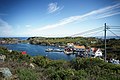
Mjørsund and Suggevågen

Sjøhus and Canal
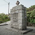
Memorial to October 13, 1899

View to Røværsholmen lighthouse

overall view


Web links
Individual evidence
- ↑ 110 inhabitants and one car - The island of Røvær . Retrieved August 29, 2018
- ↑ En tragedie . Retrieved August 23, 2018
- ↑ The Hiltahus . Retrieved August 23, 2018