
Radar plotting

In seafaring, radar plotting is the term used to describe the evaluation of the radar image in order to determine courses and speeds of echo displays. The conventional method is the graphic evaluation to predict the movement of vehicle echoes on the screen to determine whether there is a threat of unwanted approaches with other vehicles ( close-range situation ). In the commercial shipping industry, the use of ARPA systems that carry out the plot function automatically has established itself instead .
Procedure
A basic distinction is made between different types of radar plotting. These are the graphic radar evaluations with attachment, foil or on paper, as well as automated plotting with ARPA. Methodologically, a distinction is also made between relative plots and true plots.
The conventional method is the graphic radar evaluation. This can be done either using a reflection plotter attachment on the radar or on paper. When working with the plotter attachment, the radar echoes are parallax (error) -free with a grease pen and transferred to a plot disk (a transparent work surface, the function of which can partly be supported by an additional film) and sealed with a ruler . With the paper plot, all angles and distances of the echoes are measured on the radar and transferred to a worksheet for evaluation. A radar spider can be used for a relative plot, a worksheet on which concentric circles are printed at the same nautical miles distance as on the selected radar scale and which is also provided with a graduation. The lines should serve to transmit the locations of radar images and to construct movement sequences. The echo movements are calculated in advance on the worksheet using a vector addition method . True plots can be made on unlined paper.
Graphic evaluation
Calculation of the relative movement (relative plot)
The relative plot is used to calculate the relative movement of radar echoes, only the movement of the radar echo in relation to the own vehicle is calculated. The procedure is used when it comes to determining the passage distance between two ships ( smallest passage distance ) and the angle of encounter. The latter is important for the obligation to give way or the non-handicap requirement.
example
- Given:
- Own course: 045 °
- Own speed: 12 kn
- Echo 1: B 1400 o'clock / 340 ° / 8 nm
- Echo 2: B 1406 o'clock / 350 ° / 6 nm
- Searched:
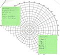
Step 1: The course of the ship is taken from the GPS and entered as a line.

Step 2: The distances of the bearings of the located echoes are determined with the help of the variable range marker (VRM) and the bearing beam. The locations are drawn in with the time as a point.

Step 3: A line is drawn through the points of the echoes. The line must cross the course of your own ship.

Step 4: Between the line of the echo points, a line is drawn to the center at an angle of 90 °. With the help of a pair of dividers , the distance can be taken and measured on circles. This line is the smallest passing distance (CPA).

Step 5: To determine the relative course of the echo, the angle of the line through the echo points to the 0 ° line is measured.

Step 6: In order to determine the relative speed of the echo, the distance between the two echo points is taken with the divider and measured on the circles. The distance between the points in relation to the time between the locations gives the relative speed.

Step 7: In order to determine what time you are at the CPA, it must be calculated when the echo, if it maintains speed and course, has covered the remaining distance between the second location and the CPA.

Step 8: In order to calculate the angle at which the ships travel to one another, the angle between the line through the echoes and your own course must now be taken.


- Result:
- CPA: 3.6 nm
- KBr: 133 °
- VBr: 24 kn
- TCPA: 1418
- SPA-B: 268 °
Calculation of the absolute movement
example
- Given:
- Own course: 045 °
- Own speed: 12 kn
- Echo 1: 1400 B 340 ° / 8 nm
- Echo 2: 1406 B 350 ° / 6 nm
- Searched:
- KB:
- VB:

First of all, as with relative plotting, your own course line and the echoes of the opponents are drawn. The line through the echoes of the opponents shows their relative direction of movement.

As a second step, a line is drawn on the first echo in the direction of the first echo with its own course and the length of the distance covered between the echoes.
As the last step, the second echo is connected to the end of the line just entered. The connecting line shows the absolute course direction of B in the direction of the second echo, the length of the connecting line corresponds to the absolute distance covered between the echoes.


- Result:
- KB: 107 °
- VB: 26 kn
Calculation of the absolute movement (true plot)
The second variant, the True Plot, is used to calculate the absolute movement; the movement of your own and that of the other ship in relation to the sea floor is calculated.
ARPA
Since the radar echoes are no longer displayed as a tube radar image on a cathode ray tube , the method of radar plotting has lost its importance. Today's display devices for radar echoes represent the image synthetically and are usually equipped with an ARPA system. With the help of computers, the movement of radar echoes can be automatically calculated in advance. If the radar and AIS data are displayed in combination, speed, course and position are also displayed directly on the radar screen.
Nevertheless, radar plotting is an important part of training in seafaring. For the recreational boating the Radarplotten is still of great importance; the small radar systems are often not able to predict echo movements or display them properly.
Legal obligation to plot radar
Rule 7 of the collision prevention rules (KVR) states:
- a) Each vehicle shall, by all available means, according to the circumstances and conditions, determine whether there is a potential for a collision hazard. In case of doubt, this option is to be accepted.
- b) In order to receive an early warning of the possibility of a risk of a collision, an existing and operational radar system must be properly used, including the use of long distance ranges, plotting or an equivalent systematic method for monitoring located objects.
Rule 19 KVR states:
- A vehicle that only uses radar to locate another vehicle must determine whether a close-range situation is developing and / or whether there is a risk of a collision.
From this it can be interpreted that every watercraft that is equipped with a radar system is obliged to use it using radar plotting. A violation of the KVR can be interpreted as gross negligence by a skipper in the event of damage.
Individual evidence
- ↑ Terheyden, Karl (ed.): Müller-Krauss, manual for ship management . Volume 1, Navigation, Part C. Springer Verlag, Berlin 1986, ISBN 3-540-13484-0 , pp. 142 .
- ↑ a b Dietrich v. Haeften, Harald Schultz: Sportseeschifferschein. Delius Klasing, Bielefeld 2010, ISBN 978-3-7688-3186-4 , p. 136.
- ^ Haeften, Schultz: Sportseeschifferschein. 2010, p. 67.
- ↑ a b c Rule 7 of the KVR