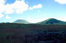
Rano Raraku
Location of Rano Raraku |
The Rano Raraku is an extinct volcano, more precisely a cinder cone , with a height of up to 150 m on Easter Island . It rises seamlessly from the grassy plain 14.7 km east of Hanga Roa . The southeast slope of the conical mountain is eroded in places. The steep edge of the edge was geologically only a very short time ago due to coastal erosion , when the volcanic cone was gnawed directly by the sea. A later lava flow from Maunga Terevaka changed the coastline so that the Rano Raraku is now about one kilometer from the ocean.
The Rano Raraku is a parasitic volcano of Terevaka, the highest point on Easter Island. The rock is a porous tuff of yellowish brown color with numerous inclusions. On the slopes of the mountain - especially in the south - you can still see the quarries from which almost all the stone figures ( Moai ) on Easter Island come. Today 397 more or less completed statues still stand halfway up around the crater rim and on the inner slopes. They are buried in the ground up to the shoulder or chest area.
In the 350 × 280 m oval crater there is a freshwater lake, one of the few open bodies of water on Easter Island whose south and east banks are densely overgrown with Totora reeds . One to two meters thick reed mats drift on the surface, which, as can be seen from a comparison of satellite images, are driven by the wind over the entire lake, so that the surface is constantly changing.
In 1958, a system of pipes was created to use the lake to supply water to a sheep farm. This measure permanently lowered the water level of today's 6 - 7 m deep lake by about one meter. Today the island has a central water supply from deep boreholes, so that water extraction from the crater lakes is no longer necessary.
Individual evidence
- ^ A b Daniel Mann et al .: Drought, vegetation change, and human history on Rapa Nui (Isla de Pascua, Easter Island); in: Quaternary Research 69, 2008, pages 16-28
- ^ Jo Anne van Tilburg: Easter Island: Archeology, Ecology and Culture; London 1994
- ↑ John R. Flenley: The Palaeoecology of Easter Iceland, and its Ecological Disaster in Easter Iceland Studies; in: Contributions to the History of Rapanui in Memory of William T. Mulloy, Oxford 1993, pp. 27-45
Coordinates: 27 ° 7 ′ S , 109 ° 17 ′ W
Web links
Easter Island in the Global Volcanism Program of the Smithsonian Institution (English)


