Redland City
| Redland City | |
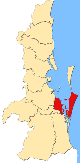
 Location of Redland City in Queensland |
|
| structure | |
| State : |
|
| State : |
|
| Administrative headquarters: | Cleveland |
| Dates and numbers | |
| Area : | 537.2 km² |
| Residents : | 147,010 (2016) |
| Population density : | 274 inhabitants per km² |
Coordinates: 27 ° 35 ' S , 153 ° 15' O Redland City is a local government area (LGA) in the Australian state of Queensland . The area is 537 km² and has about 147,000 inhabitants.
geography
Redland is located in the southeast of the state on the coast and borders the capital Brisbane to the northwest . North Stradbroke Island also belongs to the LGA .
The administrative headquarters of the LGA is located in Cleveland, which has around 14,800 residents. Other districts include Alexandra Hills, Amity, Birkdale, Capalaba, Coochiemudlo Island, Dunwich, Karragarra Island, Lamb Island, Macleay Island, Mount Cotton, North Stradbroke Island, Ormiston, Point Lookout, Redland Bay, Russell Island, Sheldon, Thorneside, Thornlands, Victoria Point and Wellington Point.
history
Redland is named after the reddish earth in the region. Redland Shire was formed in 1948 from the merger of Cleveland Shire and part of the Tingalpa Shire. In 2008 the LGA became a city.
administration
The Redland City Council has eleven members. Ten Councilors are elected by the residents of the ten divisions (constituencies). The council chairman and mayor (mayor) is also elected by all residents of the city.
swell
- ↑ a b Australian Bureau of Statistics : Redland (C) ( English ) In: 2016 Census QuickStats . June 27, 2017. Retrieved May 16, 2020.
- ↑ Australian Bureau of Statistics : Cleveland (Qld) ( English ) In: 2016 Census QuickStats . June 27, 2017. Retrieved May 16, 2020.
Web links
- Official site of the Redland City Council (English)
- Queensland Places: Redland City (English)