Roadstead (Borkum)
|
Roadstead
City of Borkum
|
|
|---|---|
| Coordinates: 53 ° 33 ′ 50 ″ N , 6 ° 45 ′ 2 ″ E | |
| Postal code : | 26757 |
| Area code : | 04922 |
|
Map of Borkum
|
|
|
Harbor and roadstead from the air
|
|
Roadstead is one of three districts on the East Frisian island of Borkum in the district of Leer in Lower Saxony . In addition to the core city, the city also includes the eastern part of the country . The port with the pier for ferries from Emden or Eemshaven is in Borkum-Reede . The name Roadstead actually means anchorage .
geography
Roadstead is in the extreme south of the island.
Infrastructure
In the buildings of the former naval seamanship teaching group of the German armed forces , which was an important naval base and largest employer on the island until the 1990s, the German Youth Hostel Association has been operating the youth hostel "Am Wattenmeer" with 611 beds since October 1996. With an area of around 20 hectares, it is also the largest of its kind in terms of area.
Rail transport
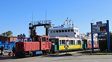
"Roads" and the port are by Inselbahn the gauge connected by 900 millimeters with the station "Borkum". The seven-kilometer, double-track line was completed in 1888 and also serves the “Jakob-van-Dyken-Weg” stop.
Bus transport
In addition to the railway line, there is an irregular bus service that runs roughly in parallel . Most of the trips are made to the Ostland , some also end at the BfA clinic .


