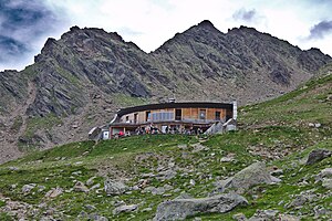
Refuge du Nid d'Aigle
| Refuge du Nid d'Aigle CAF hut |
||
|---|---|---|
| location | Haute-Savoie department ; Auvergne-Rhône-Alpes , France | |
| Mountain range | Mont Blanc group | |
| Geographical location: | 45 ° 51 '18 " N , 6 ° 48' 10.8" E | |
| Altitude | 2372 m | |
|
|
||
| owner | Saint-Gervais commune | |
| Construction type | hut | |
| Usual opening times | June 14th to September 30th | |
| accommodation | 20 beds, 0 camps | |
The Refuge du Nid d'Aigle is a refuge located in France . It is located in the Haute-Savoie department , part of the Auvergne-Rhône-Alpes region .
history
The refuge opened in 2006 after the old building fell victim to a fire in 2003.
description
The hut at an altitude of 2372 m is currently the starting point of the normal route to Mont Blanc . It is cultivated from mid-June to the end of September. The hut offers a beautiful view of the summit of the Pointe Percée, the highest point in the Aravis mountain range. The Refuge du Nid d'Aigle lies at the foot of the Aiguille de Bionnassay ( 4052 m ) and the Aiguille du Goûter ( 3863 m ).
Access
The refuge can be easily reached from the Nid d'Aigle terminus of the Tramway du Mont-Blanc mountain railway . It can be reached via a 200 m long path from the train station. Alternatively, there is an ascent from the approx. 1000 m high commune of Les Houches . The route, which takes about 4 hours, leads over the 1800 m high village of Bellevue, which can also be reached with the Tramway du Mont-Blanc or a cable car. From the parking lot du Crozat near the Refuge du Fioux , experienced hikers can reach the hut within two and a half hours, partly along the scree of the Glacier de Bionnassay glacier .
Web links
- FFCAM.fr: Refuge du Nid d'Aigle (French)
- Camptocamp.org: Refuge du Nid d'Aigle (French)
- Refuges.info: Refuge du Nid d'Aigle (French)
- Refuges-Montagnes.fr: Refuge du Nid d'Aigle (French)

