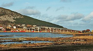
Remøybrua
Coordinates: 62 ° 21 ′ 57 ″ N , 5 ° 40 ′ 12 ″ E
| Remøybrua | ||
|---|---|---|
| The Remøybrua spans the "Nørdre Vaulen" | ||
| use | Road bridge (1-lane) | |
| Convicted | Fylkesvei 18 | |
| Crossing of | Nørdre Vaulen | |
| place | Herøy | |
| construction | Gerber girder bridge | |
| overall length | 340 m | |
| Number of openings | 18th | |
| opening | 1967 | |
| toll | toll-free | |
| location | ||
|
|
||
The Remøybrua ( German Remøy Bridge ) connects the islands of Remøya and Leinøya with each other. Both islands belong to the western Norwegian island community of Herøy in Fylke Møre og Romsdal .
The Remøybrua is a 340 m long, single-lane concrete bridge between Remøyholmen and Remøya, which was opened in 1967.
Web links
Commons : Remøybrua - collection of images, videos and audio files

