Reykjadalur (Ölfus)
| Reykjadalur | ||
|---|---|---|
|
Reykjadalsá / Djúpagil |
||
| location | Southurland , Iceland | |
| Waters | Reykjadalsá | |
| Geographical location | 64 ° 2 '24 " N , 21 ° 13' 10" W | |
|
|
||
| height | 100 to 300 m | |
| length | 3 km | |
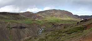
The Reykjadalur ( Icelandic Smoke Valley ) is a valley about three kilometers long in the municipality of Ölfus in Iceland , 40 km (as the crow flies ) east of Reykjavík .
geography
The valley to the north of Hveragerði extends north-south and is separated from Grensdalur to the east by Mount Dalafell . The geothermal area is traversed by the warm Reykjadalsá stream , which flows into the Varmá river after the Djúpagil gorge (literally deep gorge ) to the south . A hiking trail ( Reykjadalsleið ) runs through Reykjadalur from the Rjúpnabrekkur via Klambragil to the geothermal area of Ölkelduháls .
Web links
Commons : Reykjadalur - collection of images, videos and audio files
Individual evidence
- ↑ Reykjadalsleið: gönguleið um Reykjadal ( Icelandic ) In: Hengilssvæðið . Archived from the original on July 1, 2012. Info: The archive link was automatically inserted and not yet checked. Please check the original and archive link according to the instructions and then remove this notice. Retrieved June 27, 2012.

