Risihorn
| Risihorn | ||
|---|---|---|
|
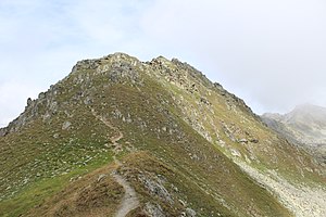
On the way to the summit of the Risihorn |
||
| height | 2875 m above sea level M. | |
| location | Bellwald , Canton of Valais , Switzerland | |
| Mountains | Bernese Alps | |
| Coordinates | 654 985 / 145987 | |
|
|
||
The Risihorn is 2875 m above sea level. M. high peak in the Swiss canton of Valais in the municipality of Bellwald .
It is considered the " local mountain " of the Bellwald community and is a lookout point in the UNESCO World Heritage Site of the Jungfrau-Aletsch-Bietschhorn mountain region . From the Risihorn the Finsteraarhorn , the Wannenhorn , the Fiescher Glacier and many other mountains of the Bernese and Valais Alps can be seen.
The easiest ascent leads from Bellwald to the chairlift - Furggulti mountain station at 2563 m above sea level. M. . From there it is about 55 minutes to the summit on the white-red-white marked hiking trail , the last 200 meters are marked white-blue-white.
Web links
Commons : Risihorn - collection of images, videos and audio files

