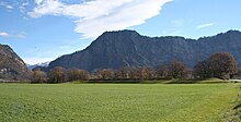
Rohanschanze
The Rohanschanze or Rheinschanze is a former star-shaped defense system in the Bündner Herrschaft in the Bündner Rhine Valley . It is included in the list of cultural assets of national importance in the canton of Graubünden . It is also listed in the ordinance on the protection of dry meadows and pastures of national importance.
investment
The remains of the ski jump are immediately east of the connecting road Landquart - Maienfeld in the municipality of Malans . A still considerable earth wall has been preserved on the north side, which, with a height of several meters and an upper width of around ten meters, gives an idea of the approximate location of the fortress in the area. The dimensions of the extremely regularly laid out facility were around 300 meters in length and around 420 meters diagonally. Only a few hills can be seen on the south and east sides.
history
During the time of the Thirty Years' War (1618 to 1648) in Europe the Protestants fought against the Catholics and the Habsburgs against the French and their allies.
The three leagues and their subject area Valtellina were an important transit area for the Spanish Habsburgs operating from Milan and the Austrians coming from the east during the Bündner turmoil . In 1631, Duke von Rohan and his corps moved to Graubünden to take command of the troops enlisted there by France. With the help of the Graubünden Protestant leader Jörg Jenatsch , he drove the Spaniards and Austrians out of the Valtellina in 1634. When the French did not want to release the Valtellina, Jenatsch turned against Rohan. In the "Landquarter Schanze" built by Johannes Ardüser from 1631 to 1635, this controlled almost all of the north-south traffic at the two only bridges over the Rhine and the Landquart .
In February 1637 the resistance against Rohan was planned in the Kettenbund . On March 21, 1637, the Graubünden people marched with 3000 men in front of the hill. The surprised Rohan had only 1000 men available and had to withdraw. The ski jump was razed later.
Memorial stone
On the cantonal road Landquart - Maienfeld there is a memorial stone erected in 1938 with the inscription Built 1631 to 1635 to protect the Three Leagues by Duke Heinrich Rohan . It shows the shape of the system on a scale of 1: 1000.
Web links
Individual evidence
Coordinates: 46 ° 58 '30.6 " N , 9 ° 33' 30.2" E ; CH1903: 761,276 / two hundred and four thousand eight hundred fifty-five


