Romeu
| Romeu | ||||||
|---|---|---|---|---|---|---|
|
||||||
| Basic data | ||||||
| Region : | Norte | |||||
| Sub-region : | Terras de Trás-os-Montes | |||||
| District : | Bragança | |||||
| Concelho : | Mirandela | |||||
| Freguesia : | União das Freguesias de Avantos e Romeu | |||||
| Coordinates : | 41 ° 32 ′ N , 7 ° 4 ′ W | |||||
| Postal code : | 5370-620 | |||||
Romeu is a place and a former municipality in northern Portugal . The place is embedded in the rough nature of the Trás-os-Montes plateau.
history
Today's place was probably created in the course of the new settlements during and after the medieval Reconquista .
In the 16th century, Romeu had been a separate municipality in the Mirandela district for some time. In the statistics of 1864 and 1878, Romeu was listed as a municipality in the Macedo de Cavaleiros district, and since the surveys of 1890 Romeu has again belonged to Mirandela.
With the arrival of the Linha do Tua railway on August 2, 1905, the station in Romeu was opened.
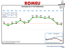
Since around 1960, the community has seen increased emigration , especially to France. The population decreased from just under 500 in 1960 to 280 in 2011.
As part of the regional reform in Portugal in 2013 , the municipality of Romeu was merged with Avantos to form a new overall municipality.
Attractions
In addition to nature, which is accessible via hiking trails of the Mirandela district administration, there are some architectural monuments in Romeu:
- Igreja da Senhora da Anunciação , the parish church of Romeu from the 16th century.
- Ponte Ferroviária de Romeu , railway bridge near Romeu, the largest on the Linha do Tua line
- Romeu train station, opened in 1905
- Fonte e Lavadouro de Romeu , stone fountain and public wash house from 1935
- Capela de Nossa Senhora de Jerusalém , chapel built in 1596
administration
Romeu was the seat of a parish of the same name ( freguesia ) in the district ( concelho ) of Mirandela in the Bragança district . The community had 283 inhabitants and an area of 14.22 km² (as of June 30, 2011).
Three localities belonged to the municipality:
- Romeu
- Vale de Couço
- Vimieiro
With the territorial reform of September 29, 2013 , the municipalities of Avantos and Romeu were merged to form the new municipality of União das Freguesias de Avantos e Romeu . Avantos became the seat of this new community.
Web links
- Entry on Romeu in the Mapas de Portugal
- Small tour of the center of the village of Romeu , 2-minute private video on YouTube
Individual evidence
- ↑ a b Entry of the parish church of Romeu in the Portuguese list of monuments SIPA, accessed on March 12, 2020
- ↑ a b Entry of Romeu train station in the Portuguese SIPA list of monuments, accessed on March 12, 2020
- ^ Entry of the Ponte Ferroviária de Romeu in the Portuguese list of monuments SIPA, accessed on March 12, 2020
- ↑ entry of Fonte e Lavadouro de Romeu in the Portuguese monument list SIPA, accessed on 12 March 2020
- ^ Entry of the Capela de Nossa Senhora de Jerusalém in the Portuguese list of monuments SIPA, accessed on March 12, 2020
- ↑ www.ine.pt - indicator resident population by place of residence and sex; Decennial in the database of the Instituto Nacional de Estatística
- ^ Publication of the administrative reorganization in the Diário da República gazette of January 28, 2013, accessed on October 1, 2014


